14% Off

Route Length

Max Altitude

Trek Duration

Trek Difficulty

Base Camp Area

Pickup Point
10+ Years Age
First timer can apply, previous trekking experience is more appreciated.
Cover 5 km of distance in 30 minutes without a stress.
+917055048487, +917055048488
trekkingcompass@gmail.com
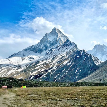
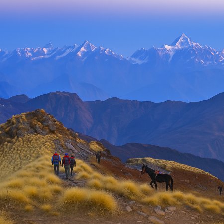
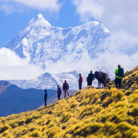
Kedartal trek is a 26 km trek with no summit point as its main attraction. Kedartal is popular for its views of Mt Thalaysagar (22,650 ft) and Mt. Bhrigupanth (22,218 ft), more Thalaysagar than Bhrigupanth. The former’s reflection in Kedartal Trek’s alpine lake stands second to none. It's majestic and every trekker should experience it.
The emerald lake between the towering mountains makes you ponder nature's wonder. Sitting there, you realize that the definition of beauty is depleting in nature. After Mt. Shivling, you have Mt. Thalaysagar, which is known for its beauty. You see why with your naked eyes standing in front of the enormous mountain.
There's not much distance between the two of you. You'll be tempted to explore more, but the weather situations there don't allow this expedition. Anytime, the clouds will cover the sky and pour down on the lake, mountain, and you. Therefore, it's important to descend as soon as you fill yourself up with Kedartal’s serene environment.
Kedartal trek isn't only about Mt. Thalaysagar. It has difficulties and Easter eggs of its own. For some trekkers, it offers the first Spider wall they cross. Others, the lucky ones get to see Bharal (Himalayan Blue Sheep). The two waterfalls and plethora of streams mid-way become the reward for some.
This trek is difficult and trekkers should come prepared. The colorful meadows here are not a walk in your park, they are high-altitude meadows at 13,230 ft to 14,250 ft. If you come unprepared, the experience will turn from pleasant to a nightmare very soon. So, are you ready for this trek?
Gangotri Altitude: 10,060 ft (3,066 m)
Altitude Gain: 8940 ft (2,723 m)
Travel Distance: 260 km
Travel Hours: 9 hrs (approx.)
Today is Day 1 of your 6-day trek to Kedartal (15,600 ft), which starts with you meeting our coordinator in Rishikesh. Then, the 9-hour journey towards Rishikesh begins as you board the respective vehicle (usually a Tata Somu). This 260 km trail does not disappoint as it is more than some spirals on the Garhwal hills. Do you remember that popular pahadi song, “Chamba Bazaara ma?” On your way to Gangotri from Rishikesh, you cross Chamba too.
This route allows you to witness both the Chandrabhaga and the Bhagirathi River. When you cross the Chandrabhaga River, you meet the Bhagirathi River. It tags along till Gangotri (considered the origin of the River Ganges, also known as Bhagirathi in these areas). The route blesses you with a distant view of Tirupati Balaji Dham, which you can visit on your way back.
After the long journey, when you reach Gangotri, you will be greeted with the Dham’s pious aura and a sea of devotees if visiting in summer. Also, you can admire an up-close view of River Bhagirathi along with the chilly air and fresh environment. At Gangotri, you can either retire to your rooms and call it a day or take short walks to acclimatize. We (Trekking Compass) will suggest the latter. If you fail to accustom to the altitude (10,060 ft), you are at a high risk of facing AMS (Acute Mountain Sickness).
Bhoj Kharak Altitude: 13,230 ft (4,033 m)
Altitude Gain: 3,170 ft (966 m)
Travel Distance: 6 km
Travel Hours: 6 to 7 hrs (approx.)
Today is the first day of trekking, and you are to go on a 6 km trail to Bhoj Kharak within 6 to 7 hrs. After breakfast at the hotel, you walk the route that also takes you to Surya Kund, Pandav Gufa, and Gauri Kund. These are three religious attractions apart from Gangotri. The trek’s trail allows you to cross Surya Kund (1st sun-ray hits this area). Your trek begins when you cross Bhairav Ghati Bridge over the Bhagirathi River. After crossing this iron bridge behind Gangotri Temple, you reach the Kedartal Trek Checkpost, 100 m. from Surya Kund.
The trail gets steeper after crossing the checkpost, and you begin to realize the trek’s difficulty. For these situations, keep a water bottle along with you, and do not forget to sip water on regular instances. This keeps you hydrated and away from the risk of AMS. The 6 km trek has three water streams to source drinking water. One is the closest to the Bhoj Kharak campsite.
After the first 300m to 400m, you enter the fir tree forest. Here, you get an aerial view of Gangotri Temple, and the trail to Gaumukh Tapovan Trek is also visible. The trail then leads you to the Bhojpatra forest, rich in Himalayan Birch trees (Bhojpatra). The barks of these trees were the papers on which the Hindu scriptures were written in the old days. Presently, locals use these barks in their shoe soles to insulate themselves from this area’s freezing cold.
After a trek of 4.5 km, you reach the challenge of the day, A Spider Wall. Here, you cross a rock wall inclined at a 60° angle. Put one foot forward at a time, and follow our technical guide’s instructions to easily cross this patch. In the next 1.5 km, you cross boulder areas, landslide zones, and a waterfall to finally reach Bhoj Kharak.
Kedar Kharak Altitude: 14,250 ft (4,343 m)
Altitude Gain: 1,020 ft (311 m)
Travel Distance: 4 km
Travel Hours: 4.5 hrs (approx.)
Your morning begins at Bhoj Kharak today, a campsite recognized by its narrow valley and a tin shed with a green roof. Today’s 4 km trek gives you time to recover from yesterday’s strenuous one. You get only a few rough patches in this trail. After crossing a white wildflower garden-like vast land for 2 km of the trek, the trail goes beside Kedar Ganga and on a raw mountain of mud and stone. It is highly prone to landslides and during rainfall. Trekkers cross the river and trek on the parallel side to be safe from being caught in a disastrous situation. Here, the trail’s beauty lies in the soothing crinkling of water flowing down the Kedar Ganga.
After this steep ascent of 25 to 30 minutes, the trail opens up to alpine meadows (little flat, lesser stones). There, tall and colorful (red, yellow, and green) grass is all around. It makes for a handpainted scenery whose perfection can keep one spellbound. You encounter a waterfall while crossing this meadow and finally reach a water stream. It is the point where you see the Manda 1 peak for the first time. After a 0.5 km steep ascent after this stream, a valley welcomes you. It is none other than Kedar Kharak (Campsite 2).
Kedar Kharak has the same different colored grass, a vast valley full of grass and streams coming down from the glaciers. These streams will eventually form the Kedar Ganga, the River Bhagirathi, and finally the River Ganga. The views from this campsite are lit with the beautiful sunset between the Bhrigupanth ranges. The orange hue scattered over the valley makes it shine unusually brighter. If you are lucky, you can spot Bharal (Himalayan Blue Sheep) grazing in this valley. If not, Mt. Thalaysagar’s peak keeps you company.
Kedartal Altitude: 15,600 ft (4,755 m)
Altitude Gain/Loss: 1,350 ft (411 m)
Travel Distance: 3 km + 3 km = 6 km (approx.)
Travel Hours: 7.5 hrs (approx.)
The day starts with a newfound enthusiasm in the strained trekkers, courtesy of the Kedartal Lake or the ‘emerald lake.’ This ‘Tal’ is 3 km from Kedar Kharak, and this trail gets strenuous and less appealing with increasing altitude. For the first 0.5 km, you have the colorful meadow and glacial streams to greet you. Soon, you leave the greenery behind and enter the boulder area with rock, dust, and barrenness to see. The chilly winds here remind you that you will see some snow. After another 1 km, light snow starts to appear.
Snow-covered, rough rocks make a perfect fit to facilitate a slip. Therefore, you should walk carefully. There is no hurry as we start early and have enough time to return to Kedar Kharak. There are hardly two water streams in the way, so you must carry ample water to keep yourself hydrated.
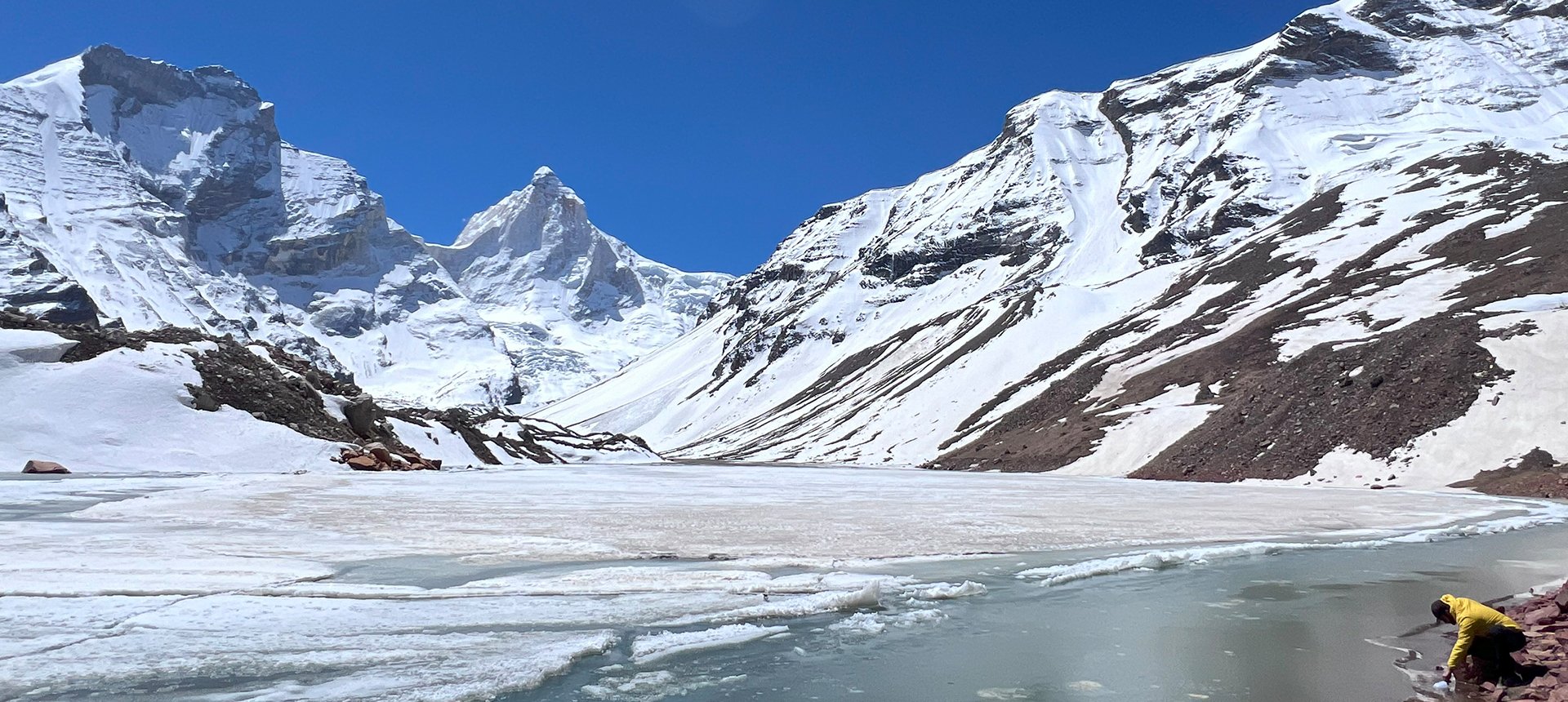
Soon enough, you reach a ridge. Mt. Thalaysagar’s view from here becomes more prominent. To reach Kedartal at 15,600 ft, you must descend for another 20 to 30 minutes. Kedartal, the alpine lake, is in front of you in all its glory, and even more glorious is the reflection of Mt. Thalaysagar on the lake.
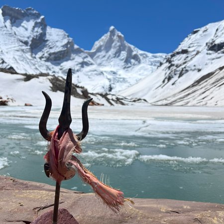
Another attraction at Kedartal is a small shrine of Lord Shiva on a bug rock beside the river. Then there are the undeniable views of Mt. Meru, Bhrigupath Ranges, Mt. Manda, and Gangotri. The lake gets its charm from the up-close view of Mt. Thalaysagar. It appears as if the mountain emerges out of the lake. After spending some time here, taking in the surreal beauty, it is time to return as the weather here is unpredictable and can rain anytime.
Gangotri Altitude: 10,060 ft (3,066 m)
Altitude Loss: 4,190 ft (1,277 m)
Travel Distance: 10 km (approx.)
Travel Hours: 8 hrs (approx.)
Today, you are in for a time travel as you trek down the route and back to the guesthouses in Gangotri. The journey begins with breakfast at Kedar Kharak, where you view Mt. Thalayasagar for the last time till you return. The Kedar Ganga River will bid adieu as you cross the Bhairav Ghati Bridge and meet River Bhagirathi, your companion hereon.
Kedar Kharak campsite’s pristine grassland and the narrow valley at Bhoj Kharak will all be left behind. You now have memories of those narrow and steep trails, the streams, the vibrant wildflowers, the Bhojpatra forest, and the colorful grass. Be careful while descending, especially while crossing the raw boulder areas, landslide zones, streams, and the Spider Wall.
Like your trek up the trail, you get plenty of fresh, rich-in-mineral water sources. Keep yourself hydrated during the trek to enjoy the descent and stay at Gangotri in the evening. If your body allows, and you are there in summer, catch the evening Ganga Arti. This day ends with dinner and a good night’s sleep.
Rishikesh Altitude: 1,120 ft (340 m)
Altitude Loss: 8940 ft (2,723 m)
Travel Distance: 250 km
Travel Hours: 9 hrs (approx.)
Today, early in the morning, you will get a chance to get Dharshans at Gangotri. For others, it is time to turn back and board vehicles for Gangotri after breakfast at your guest house. This day is not as adventurous as the others, but you find meaning as you get the flashbacks of the trek you just completed.
Bidding farewell to the beautiful temple, revered by millions of Hindu devotees, you go down the spiraling roads of mountains. This Dham is popular because of King Bhagirath’s penance to free 60,000 ancestors. Here, Lord Shiva (Mahadev) and Maa Ganga have important roles too. Gangotri is on the banks of River Ganga and is backed by vast Fir forests. It is the perfect environment for a retreat and relaxation, apart from its religious significance.
The route back to Rishikesh surprises you as you cross the famous Tehri Dam. For devotees, the route has Maa Shree Bhadrakali Mandir (right after crossing the Chandrabhaga River). This day has other opportunities like the en-route tourist attraction Bemuda Fall and Forest Garden. Besides all this, you have your end destination (Rishikesh) to look up to. It has all an explorer from a busy place desires, short hikes, white water rafting, etc. Not to mention, the Yoga Capital of the world also hosts Beattles’ fans year after year.
Accommodation
Meals (Vegetarian only )
Nutritious meals from Day 1's dinner to last day's breakfast, following the itinerary schedule.
Expert Support
First Aid Preparedness
Fully equipped medical kit including a stretcher, oxygen cylinder, blood pressure monitor, oximeter, and stethoscope to ensure safety throughout the journey.
Storage Facilities :- A secure room at the base camp to store additional luggage not needed during the trek.
Permits and Entry Fees :- Coverage of all necessary permits and entry fees, in line with standard charges for Indian nationals.
Transportation :- A round-trip transport from the pick-up point and back at the same point as a part of the itinerary.
Trek Equipment
Insurance :- Personal insurance is mandatory and not included in the package.
Personal Expenses :- Any expenses of a personal nature, including shopping, snacks, hiring a mule or porter for carrying your belongings, or acquiring personal equipment.
Emergency Costs :- Expenses arising from emergency evacuations, hospitalization, or any medical treatments required.
Unspecified Services :- Any services or items not explicitly mentioned under the "INCLUSIONS" section.
Food Costs :- We will not cover any food costs during your transit to and from the base village.
Trekking is not only about enjoying the change of scenery but also about being responsible. Our (Trekking Compass) responsibility is to provide you with an opportunity for a safe trek. But, how do we do that? We do that when you fulfill your end of the responsibility and are honest with us. To keep you safe we need to be sure there isn’t any inherent threat to your being.
Treks are at higher altitudes and it becomes difficult, almost impossible to provide you with immediate medical assistance. Therefore, we cannot help you if you don’t help us. Trekking is only one of the things you can do, but there are plenty of other things to do too. Don’t risk your life for the thrill.
To approach a trek with utmost safety, we want you to submit the following documents:
Personal Confirmation Statement (Compulsory for anyone over 18 years)
You are participating in a trek at high altitudes and it comes with its own sets of risks. This Personal Confirmation Statement will make sure that you understand all the risks you're buying into. Trekking Compass wants you to confirm your complete understanding of these risks so that you come prepared for any mental or physical challenges ahead.
This statement is also a declaration from you that, "All the information I have provided, including medical conditions, is true. If found false under any circumstances, I will be held accountable and it has nothing to do with Trekking Compass."
We have the utmost empathy for you and will do our best to help wherever possible, but only after assessing your readiness and safety for the trek. This is how our team will adequately prepare for whatever risks we might face during the journey. Concerning individuals are requested to thoroughly cross-check the requirements and only then sign the document.
Parent/Guardian Approval Statement (Compulsory for anyone below 18 years)
For participants under 18 years of age, the Parent/Guardian Approval Statement is essential to confirm that a legal guardian understands and consents to the participation in the trek. Once we have this document, we are affirmed that the parent or guardian is fully aware of the risks involved in trekking at high altitudes and is consenting to their child's participation.
No underage (below 18+) children are welcome on the trek without their parent's consent. Submission of this document reassures us that parents are approving that their child meets the health and fitness requirements for the trek, after a thorough examination.
This legal confirmation holds the parent liable for any discrepancies, freeing Trekking Compass from any liabilities for the same. Parents are requested to thoroughly cross-check the requirements and only then sign the document.
Medical Liability Waiver
The Medical Liability Waiver makes sure participants acknowledge the health risks associated with trekking at high altitudes. Common ailments during treks include altitude sickness, dehydration, muscle cramps, hypothermia, and fatigue, all of which can significantly affect your trekking experience. Additionally, weather changes and the physical demands of the terrain may exacerbate pre-existing conditions.
If you have pre-existing medical conditions such as asthma, diabetes, or heart issues, it’s vital to inform us and carry your necessary medications. Trekking Compass cannot provide immediate medical assistance in remote areas, so having the essential medications, such as inhalers, insulin, or any other prescriptions, is crucial for your safety during the trek.
By signing this waiver, you confirm that you are in good health and have taken the necessary precautions. You acknowledge these risks and agree not to hold Trekking Compass liable for any medical issues or accidents that may arise during the trek.
For any further doubts about anything mentioned above, below is our contact information:
OFFICE ADDRESS: Lane No. 4 Krishna Vihar Mohkampur, Dehradun, Uttarakhand, 248005
PHONE NUMBER: +91 7055048487, 7055048488
EMAIL ADDRESS: info@trekkingcompass.com
HOW TO REACH ? (RISHIKESH)
Note: Keep a buffer day in your getaway in addition to the total days in the itinerary. This day will come in handy in case of any political unrest, landslides, or rains. If not, you can use the extra day to get to know Rishikesh. This means that for an itinerary ending on the 15th of a month, book your return tickets for the 16th.
What are the different ways to reach Rishikesh?
On the Kedartal Trek, our first long-day trip is from Rishikesh to Gangotri (260 km). Therefore, trekkers need to reach Rishikesh to start the trek. The first move to reach Rishikesh for any trekker is to reach either Dehradun or Delhi. Later, every trekker can choose their choice of transport. The available transports for Rishikesh are:
Medium: BUS
A Friendly Note: You should travel by government buses instead of private ones because the private buses tend to take more time than expected. To avoid missing the pick-up time, try traveling by government bus, wherever possible.
Medium: TRAIN
Medium: FLIGHT
Fly Directly to Dehradun and then to Rishikesh: To fly directly at Jolly Grant Airport Dehradun, there are multiple flights from metropolitan cities. The companies that facilitate these flights are:
Fly to Delhi then take a bus or train to Rishikesh: It’s very easy to fly to Delhi from anywhere in the country and take a bus to Rishikesh. You will find a detailed description of buses in the BUS section. The companies that facilitate these flights to Delhi are:
Note: Make sure that the mode of transport you choose should bring you to Rishikesh a day before Day 1, i.e., Day 0. You can fly to Delhi and Dehradun from Mumbai, Kolkata, Bengaluru, Chennai, Hyderabad, Pune, and to Dehradun from Delhi too.
What happens on the drop-off day
Here are the points that explain your drop-off:
Special Case: What if you miss our pick-up?
You shouldn't panic and follow one of the below-mentioned ways to Lohanjung:
| Backpack with rain cover / Trolley Bag | Main bag for gear. |
| Day pack with rain cover (20 - 30 L) | For day essentials, if the main pack is off-loaded. |
| Walking stick | Recommended (at least one). |
| Water bottle/ Hydration pack | 2 bottles (1L each) or 1 hydration pack and 1 bottle. |
| Snacks | Energy bars, dry fruits, ORS/electrolytes. |
| Personal Medical Kit | As prescribed by your doctor. |
| T-shirts (Synthetic, quick-dry) | 2 full-sleeve, 2 half-sleeve. |
| Fleece T-shirts | 2 pieces. |
| Wind-stopper / Fleece jacket (upper) | 1 piece. |
| Windproof jacket | 1 piece |
| Down feather / Hollow jacket | 1 piece |
| Thermal innerwear (Upper & Lower) | 1 set. |
| Trekking pants (Synthetic, quick-dry) | 3 pairs. |
| Wind-stopper / Fleece pants (lower) | 1 pair. |
| Waterproof gloves | Not required. |
| Fleece / Woolen gloves | 1 pair. |
| Poncho / Waterproof jacket and pants | 1 set. |
| Head torch / Hand torch | 1 piece. |
| Sun cap | Required. |
| Woolen cap | 1 piece. |
| Balaclava | 1 piece. |
| Buff/ Neck gaiters | 1 synthetic, 1 woolen. |
| Sunglasses | UV protection with side covers (for spectacle users: contacts or photochromatic lenses). |
| Trekking shoes (waterproof, high ankle, good grip) | 1 pair. |
| Floaters / Flip-flops | 1 pair. |
| Cotton socks | 4 pairs. |
| Woolen socks | 2 pair. |
| Sunscreen | 1 piece. |
| Moisturizer | 1 piece. |
| Lip balm/ Chap-stick | 1 piece. |
| Toothbrush and toothbrush | 1 set. |
| Toilet paper and wipes | 1 pack each. |
| Soap/ Hand sanitizer | 1 piece. |
| Quick-dry towel | 1 piece. |
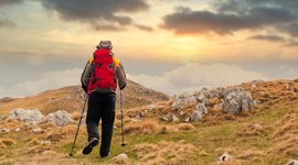
The Kedartal Trek is one of the most dramatic high-altitude treks in Uttarakhand, leading to the glacial lake Kedartal (4,750 m), which lies at the base of the mighty Thalay Sagar (6,904 m) and other snow giants like Bhrigupanth, Jogin group, and Gangotri peaks. The trek is located near Gangotri and is known for its rugged terrain, raw adventure, and spectacular mountain reflections in the turquoise waters of Kedartal Lake. Unlike meadow treks such as Dayara Bugyal or Ali Bedni, Kedartal is a true glacier trek that tests stamina and endurance, rewarding trekkers with an unforgettable Himalayan setting that feels untouched and divine.
The best windows are:
Kedartal is considered a difficult trek. The trail is steep, rocky, and demanding, with sections involving boulder-hopping, narrow ridges, and moraines. The altitude of nearly 4,750 m adds to the challenge, requiring trekkers to be well-acclimatized and fit. This trek is not suitable for beginners; it is recommended only for experienced trekkers who have previously completed Himalayan treks above 3,500–4,000 m.
The trek is about 37 kms (round trip) and typically takes 6 days. Starting from Gangotri (3,100 m), the route passes through Bhoj Kharak and Kedar Kharak before reaching Kedartal. Each day involves 5–8 hours of trekking, often with steep ascents on rocky trails.
The trek culminates at Kedartal Lake at 4,750 m (15,500 ft). This altitude makes it one of the highest trekking destinations in Uttarakhand. Standing at the lake, trekkers are surrounded by towering peaks such as Thalay Sagar, Jogin I–III, Bhrigupanth, and Meru. The reflection of Thalay Sagar in Kedartal Lake is one of the most breathtaking Himalayan sights.
Yes, Kedartal trek is strictly for experienced trekkers. You should have completed at least 2–3 Himalayan treks above 3,500 m before attempting Kedartal. The technical sections, steep ascents, and high altitude make it unsuitable for beginners.
Trekkers must have excellent stamina and endurance. You should be able to jog 5 km in under 30 minutes and walk uphill with a backpack for 6–8 hours daily. Training should include cardio (running, swimming, cycling), strength workouts (squats, lunges, planks), and trekking practice with a loaded backpack.
Kedartal holds spiritual importance as it lies in the Kedar region, associated with Lord Shiva. Many locals believe that Kedartal is blessed by Shiva himself, and the surrounding mountains are considered sacred. The trek begins at Gangotri, one of the Char Dham pilgrimage sites, adding a spiritual dimension to the adventure. For many trekkers, reaching Kedartal feels like a pilgrimage, not just a trek.
At Gangotri, trekkers can find lodges, hotels, and dharamshalas. Beyond Gangotri, accommodation is limited to campsites — Bhoj Kharak, Kedar Kharak, and Kedartal. Camping is raw and adventurous, with tents set up on rocky grounds or meadows. Facilities are basic, and trekkers must be prepared for wilderness camping.
Yes. Since the trek falls within Gangotri National Park, entry permits are required. Permits can be obtained from the forest office at Uttarkashi or Gangotri. Trekking without permits is not allowed, and there is a daily cap on the number of trekkers to protect the fragile ecosystem.
The trek begins at Gangotri (3,100 m).
Yes. At 4,750 m, the risk of Acute Mountain Sickness (AMS) is real. Symptoms include headache, nausea, and dizziness. Proper acclimatization, hydration, and a steady pace are essential. Trek leaders usually carry oxygen cylinders and first aid, but trekkers must be cautious and inform guides immediately if symptoms occur.
Yes, when done with experienced guides (like guides of Trekking Compass). However, it is a challenging trek with inherent risks — steep climbs, loose rocks, and high altitude. Solo trekking is not recommended. With proper guidance, gear, and fitness, the trek is safe for seasoned trekkers.
Because it is one of the most rewarding glacier treks in Uttarakhand. For those who seek raw adventure, solitude, and towering Himalayan giants at close quarters, Kedartal delivers an unmatched experience. It is not a casual trek, but for trekkers who want to push their limits, Kedartal offers the perfect mix of challenge, spirituality, and breathtaking scenery. Standing by the turquoise waters of Kedartal with Thalay Sagar towering above you is a memory that stays forever.
Preparing for Kedartal trek means:
Our trek leaders are trained in first aid and equipped with oxygen cylinders and stretchers. The nearest medical facilities are available at Gangotri, and evacuation arrangements are made if required. Travel insurance covering trekking is strongly advised.
Yes, trekkers who don’t wish to carry their backpack can opt for mule/porter services at an extra cost. This allows you to trek light while still enjoying the Kedartal Trek experience.
Handpicked routes with strong scenery, reliable pacing, and a premium featured block that still stands apart from the rest of the archive page.
Crafted routes, reliable execution, and a trekking experience that feels premium from planning to summit.
 Safety
Route checks, first-aid readiness, and trained leaders to keep every step confident.
 Routes
Better pacing, better camps, and real acclimatization designed for experience, not speed.
 Groups
Less crowd, more care so you enjoy the trek, not just finish it.
 Trust
Trust
Clear inclusions, no hidden surprises, and real human support on WhatsApp.