19% Off

Route Length

Max Altitude

Trek Duration

Trek Difficulty

Base Camp Area

Pickup Point
10+ Years Age
First timer can apply, previous trekking experience is more appreciated.
Cover 5 km of distance in 30 minutes without a stress.
+917055048487, +917055048488
trekkingcompass@gmail.com
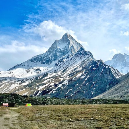
The Bali Pass Trek, unlike other treks, is not famous for its views. This trek is popular for the range of spots one can explore on this trek. Famously, it is known for connecting the Har Ki Dun Valley to the Yamunotri Valley. Midway, you can explore places like Osla Village, Yamunotri Dham, Ruinsara Tal, Devsu Bugyal, etc.
Bali Pass trek is not a definite outcast of treks in all cases as it also offers views of Swargrohini Peak, 360॰ view of Bandarpooch 1 and 2 Peaks (White Peak), Black Peak (Kala Nag Peak), etc. Summit climb-like grand experience is also a gift of Bali Pass Trek when trekkers climb the 16,220 ft point on the Bali Pass Trek. Other Garhwal Himalayan peaks are also in the view-vicinity of the Bali Pass trek.
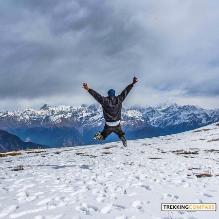
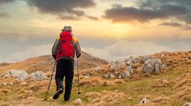
This 8-day trek is your chance to have an all-round experience. You have rivers, waterfalls, streams, makeshift bridges, rare Himalayan bears, forest patches, alpine meadows, mountain peaks, valleys and religious and cultural sightings. If not this all, you can always boast that you went on a trek that requires extreme fitness levels. Yes, Bali Pass Trek is not for every enthusiast. This trek is for religious trekkers, is that you?
Sankri Altitude: 6,400 ft (1,960 m)
Altitude Gain: 4300 ft (1311 m)
Travel Distance: 220 km
Travel Hours: 10 hrs
The start of your trekking adventure begins with meeting our travel associates. They join you at Dehradun and get you safely to Sankri (6,400 ft). Among many Himalayan villages, this is one beautiful and must-visit sight. The drive to the base village also has occasional river views. Otherwise, this day is only lightly packed.
Trekkers have to sit back, rest, and zoom into the spirals of the Garhwal hills. Let yourself get carried away by the beauty of hilly roads. Here at once you are at the base of the hill and then suddenly at the top of the same hill.
Travel-sick trekkers can relax, they need not talk to anyone to feel accompanied. They have plenty of company in the form of ravishing views of the Yamuna River and the sound of its soothing flow. If strong smells make you nauseous, worry not, the sweet smell of pines will keep your senses balanced.
It's a 10-hour drive to Sankri, approximately 220 km from Dehradun. After Kotgaon, the drive left is as minimal as 3 minutes. Kotgaon hosts basecamps for Kedarkantha Trek just like Sankri. Both Kotgaon and Sankri are under the Govind Pashu Vihar Wildlife Sanctuary. The exotic flora this wildlife sanctuary houses is worth a visit if time allows.
Taluka Altitude: 7,200 ft. (2195 m)
Seema Altitude: 8,500 ft. (2,590 m)
Altitude Gain: 4,200 ft (1280.1 m)
Travel Distance: 12 km + 14 km
Travel Hours: 50 mins (drive) + 7 hrs (trek)
It's a day with two adventure types intermingled: a long drive on mountain trails. The end goal for today is “Reach Seema.” This riverside campsite takes time to reach and therefore the day starts early. First, the trekkers will board a vehicle (usually a jeep) and reach Taluka (2,195 m) after an hour-long drive. Taluka onwards, you are on your own as the trek begins, with no taxis, only legs. Rest, get pumped up at Taluka, and trek downwards to the Tons River’s sides.
Soon, the trail throws several bridges and forest patches your way. The first forest patch is a coniferous forest, on its end is a cemented bridge coupled with a beautiful stream. The trekkers cross a wooden bridge later, which comes with an accessible stream of fresh water. Make sure you refill your drinkable water quota here.
Once you cross the Tons River, your eyes will see flower beds rich in exotic species of flora and fauna. Rare Himalayan Wildlife is seen in this area. Although, the stars of this day aren't the streams, flora, and fauna, but the locals who'll entertain you wholeheartedly. Their love for their local culture and legends overflows when they readily share these stories as soon as you show the slightest interest. This day ends with Seema (2,590 m); a beautiful campsite to rest after the 12 km drive and 14 km trek day.
Devsu Bugyal Altitude: 9,800 ft (2,987 m)
Altitude Gain: 1300 ft (396 m)
Travel Distance: 10 km
Travel Hours: 7 hrs (approx.)
This morning, you leave Seema (the last village) behind for your next campsite, Devsu Bugyals. The trail to Devsu Bugyals is rough and you encounter a few steep climbs.
The way to Devsu Bugyals is rich in Oak forest, and the trees lining the trail are majestic. If you didn't miss the movie Twilight, you know the magic of oak forests and high cliffs.
This trail has it all along with the usual streams here and there. During winters, these trees are covered in white, forming a winter of some sort.
After a 10 km trek, you reach Devsu Bugyal, a vast clearing amid mountains. It's also lined with forests of oaks, the trees appear as if they froze in their attempt to climb atop Devsu Bugyal (9,800 ft).
The camps for rest are set in Devsu Bugyal and you get perfect views of the night sky. Hills after hills unfold in front of you as you lay in your camp. Each hill is lined and made sharper with its coniferous trees. The icing on these cake-like hills are the clouds perched on top of them and in the valleys.
Ruinsara Tal Altitude: 11,750 ft (3,581 m)
Altitude Gain: 1950 ft (594 m)
Travel Distance: 7 km
Travel Hours: 5 to 6 hrs (approx.)
It's time for the first stop point of this trek that'll keep you spellbound: The Ruinsara Lake. For it, take the forest trail descending steeply from Devsu towards the Ruinsara River. This sharp and quick descent needs to trek carefully for 15 minutes before you reach a wooden bridge. Cross the bridge and you will also cross the Ruinsara River.
While crossing, look to your right at the beauty of Ruinsara Valley. The trail now takes you inside this valley where the river flows on your right. The next 50 minutes of your path will alternate flat stretches and gradual climbs. The terrain will have boulders and pasture land patches, all by the river. Now is a good time to rest and have your packed food.
Beyond this point, you'll observe a quickly deteriorating trail further into the valley. These landslide-prone zones call for an extra careful and conscious walk. The deteriorating trail ends at a waterfall you encounter on this trail. Once you cross the waterfall, a steep climb starts again and gets you to meadows covered in glacial snow more than grass.
Away from the Untigad campsite by around 45 minutes, you get a meadow again. Later you cross another river to rejoin the trail to a makeshift bridge over Ruinsara River. You continue your trek from here for 50 more minutes to reach Ruinsara Tal. This trail takes you through a birch forest until you see a hut in front of you. Right there, below on your left is the Ruinsara Tal, and on your right flows the Supin River.
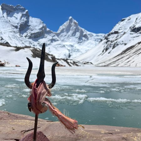
This campsite doesn't only have the Ruinsara Tal, but also views of White Peak, Kala Nag Peak, Bandarpoonch Peak, and Dhumdhar Kandi Range. The night sky, lit with stars is the other added benefit of this campsite.
Odari Altitude: 13,150 ft (4,008 m)
Altitude Gain: 1,400 ft (427 m)
Travel Distance: 4 km
Travel Hours: 3 to 4 hrs (approx.)
Today is all about trekking a bit closer to the Bali Pass. There are no hectic kilometers, only a 4-km trek to Odari, a village with a story related to Bali. Villagers believe that Bali, Sugreev’s brother from Ramayana rested for a night here. It's named Odari, which translates to “rock cave.”
At 13,150 ft (Odari) you can expect the temperatures to get low and oxygen levels to drop. This day gives you time to acclimatize for the final climb on Day 7.
This campsite also has views of Swargrohoni massifs, they are not very prominent but still beautiful nonetheless. On your trek to Odari, you'll cross a bridge, Bugyals, and rocky lands. After this, you get some rest for trekking to Bali Col Camp tomorrow.
Bali Col Camp Altitude: 15,200 ft (4,633 m)
Altitude Gain: 2,050 ft (625 m)
Travel Distance: 5 km
Travel Hours: 7 hrs (approx.)
Another day, another trek, but today's a more promising trek because the end goal is Bali Col Camp. Hereafter, Bali Pass Trek is only a few hours distance.
This trek's difficulty levels increase gradually hereinafter. It's steep at an angle of 60°. The ridge walk takes 7 hrs (approx.) for a 5 km trek as it's a steep climb with a gradual decline in temperature and oxygen levels.
Trekkers should carry around 2 to 3 liters of water because Odari is the last campsite with any fresh water source. Hydration of essence in a place with high risks of AMS (Acute Mountain Sickness). Keep yourself hydrated and follow instructions to enjoy the experience.
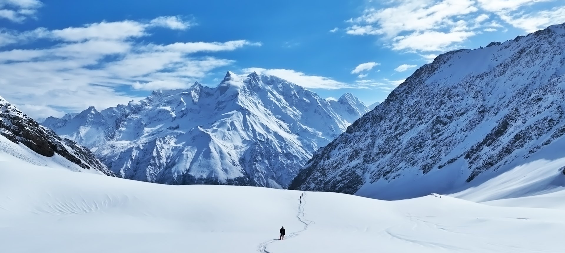
Bali Pass Altitude: 16,220 ft (4,944 m)
Lower Dhamni Altitude: 10,100 ft (3,078 m)
Altitude Gain: 1,020 ft (311 m)
Altitude Loss: 6,120 ft (1,865 m)
Travel Distance: 15 km
Travel Hours: 11 to 12 hrs (approx.)
Today is the summit day for everyone waiting to reach the highest point on this trek, 16220 ft. The Bali Pass trek is not a summit trek, but we can refer to the highest point as the summit seeing its grandeur and difficulty.
It’s a long trek day today with a considerable altitude gain of 311m and a loss of 1,865 m. The trekkers have to survive ⅓ rd the oxygen levels of a normal region here making this a limited trek. Unfortunately, everyone cannot do it, only trekkers with high fitness levels are eligible.
Your trek begins at the Bali 15,200 and you gradually trek to Bali Pass at 10,100 ft. This pass is majestic in what it offers even without a summit point. Its offerings involve 360॰ views of the Bandarpoonch ranges (especially Bandarpoonch 1 and 2). Then at your back, you have the Swargrohini peak in all its glory appearing like it’s following suit.
The climb to 16,220 ft, is quite challenging for the last 10 ft trail. It can only accommodate 20 to 30 people at a time. Once you are past this and on the summit, you get a sense of achievement, to which the Yamunotri Valley view adds more joy.
Last is the descent to the lower Dhamni campsite to retire after a 15-km trek. It is difficult and gets very steep and narrow, increasing the fear of falling on either side of the ridge. You will know you are nearing the campsite after passing through a forest cover. Trekkers should stick together with experienced guides, and it will not be difficult in the end.
Janki Chatti Altitude: 8,300 ft (2,530 m)
Dehradun Altitude: 2100 ft (640 m)
Altitude Loss: 8,000 ft (2,438 m)
Travel Distance: 8 km (trek) + 174 km (drive) = 182 km (approx.)
Travel Hours: 4 hrs + 8 hrs = 12 hrs (approx.)
It's the last day of this 8-day trek, and you reach Dehradun by the end of it. But, before that, you will be in lower Dhamni Forests, Janki Chatti, Yamunotri, Barkot, Naugaon, Mussoorie, etc. If routes vary, you might miss Mussoorie and see Selakui instead.
The morning starts with a 30-minute trek on a trail through the lower Dhamni Forests and connects to the old Yamunotri Trail. Thereon, you can trek 5 km up and back to see Yamunotri temple or trek down to Janki Chatti.
At Janki Chatti, you board vehicles for Dehradun. From Janki Chatti to Yamuna Bridge, River Yamuna is your companion. On reaching Dehradun, you can stay the night or travel to your home at your convenience. All you permanently take with you are the memories and experiences of this incredible trek.
Accommodation
Meals (Vegetarian only with eggs option available)
Nutritious meals from Day 1's dinner to last day's breakfast, following the itinerary schedule.
Expert Support
First Aid Preparedness
Fully equipped medical kit including a stretcher, oxygen cylinder, blood pressure monitor, oximeter, and stethoscope to ensure safety throughout the journey.
Storage Facilities :- A secure room at the base camp to store additional luggage not needed during the trek.
Permits and Entry Fees :- Coverage of all necessary permits and entry fees, in line with standard charges for Indian nationals.
Transportation :- A round-trip transport from the pick-up point and back at the same point as a part of the itinerary.
Trek Equipment
Insurance :- Personal insurance is mandatory and not included in the package.
Personal Expenses :- Any expenses of a personal nature, including shopping, snacks, hiring a mule or porter for carrying your belongings, or acquiring personal equipment.
Emergency Costs :- Expenses arising from emergency evacuations, hospitalization, or any medical treatments required.
Unspecified Services :- Any services or items not explicitly mentioned under the "INCLUSIONS" section.
Food Costs :- We will not cover any food costs during your transit to and from the base village.
Trekking is not only about enjoying the change of scenery but also about being responsible. Our (Trekking Compass) responsibility is to provide you with an opportunity for a safe trek. But, how do we do that? We do that when you fulfill your end of the responsibility and are honest with us. To keep you safe we need to be sure there isn’t any inherent threat to your being.
Treks are at higher altitudes and it becomes difficult, almost impossible to provide you with immediate medical assistance. Therefore, we cannot help you if you don’t help us. Trekking is only one of the things you can do, but there are plenty of other things to do too. Don’t risk your life for the thrill.
To approach a trek with utmost safety, we want you to submit the following documents:
Personal Confirmation Statement (Compulsory for anyone over 18 years)
You are participating in a trek at high altitudes and it comes with its own sets of risks. This Personal Confirmation Statement will make sure that you understand all the risks you're buying into. Trekking Compass wants you to confirm your complete understanding of these risks so that you come prepared for any mental or physical challenges ahead.
This statement is also a declaration from you that, "All the information I have provided, including medical conditions, is true. If found false under any circumstances, I will be held accountable and it has nothing to do with Trekking Compass."
We have the utmost empathy for you and will do our best to help wherever possible, but only after assessing your readiness and safety for the trek. This is how our team will adequately prepare for whatever risks we might face during the journey. Concerning individuals are requested to thoroughly cross-check the requirements and only then sign the document.
Parent/Guardian Approval Statement (Compulsory for anyone below 18 years)
For participants under 18 years of age, the Parent/Guardian Approval Statement is essential to confirm that a legal guardian understands and consents to the participation in the trek. Once we have this document, we are affirmed that the parent or guardian is fully aware of the risks involved in trekking at high altitudes and is consenting to their child's participation.
No underage (below 18+) children are welcome on the trek without their parent's consent. Submission of this document reassures us that parents are approving that their child meets the health and fitness requirements for the trek, after a thorough examination.
This legal confirmation holds the parent liable for any discrepancies, freeing Trekking Compass from any liabilities for the same. Parents are requested to thoroughly cross-check the requirements and only then sign the document.
Medical Liability Waiver
The Medical Liability Waiver makes sure participants acknowledge the health risks associated with trekking at high altitudes. Common ailments during treks include altitude sickness, dehydration, muscle cramps, hypothermia, and fatigue, all of which can significantly affect your trekking experience. Additionally, weather changes and the physical demands of the terrain may exacerbate pre-existing conditions.
If you have pre-existing medical conditions such as asthma, diabetes, or heart issues, it’s vital to inform us and carry your necessary medications. Trekking Compass cannot provide immediate medical assistance in remote areas, so having the essential medications, such as inhalers, insulin, or any other prescriptions, is crucial for your safety during the trek.
By signing this waiver, you confirm that you are in good health and have taken the necessary precautions. You acknowledge these risks and agree not to hold Trekking Compass liable for any medical issues or accidents that may arise during the trek.
For any further doubts about anything mentioned above, below is our contact information:
OFFICE ADDRESS: Lane No. 4 Krishna Vihar Mohkampur, Dehradun, Uttarakhand, 248005
PHONE NUMBER: +91 7055048487, 7055048488
EMAIL ADDRESS: info@trekkingcompass.com
HOW TO REACH? (Dehradun)
Note: You are in for trekking in the mountain areas, here the probability of landslides, rains, etc. are very common. Sometimes political unrest also becomes the reason for hindrance in your trek itinerary. Therefore, while booking your return tickets, keep a buffer day. For instance, if your trek is 6 days long, book a return ticket for the 7th day.
What are the different ways to reach Dehradun?
Bali Pass trek starts at Dehradun and takes you on a long drive (220 km) to Sankri. Therefore, trekkers need to reach Dehradun to start the trek. The first move for trekkers to reach Dehradun is to reach Delhi. Later, every trekker can choose their choice of transport. The available transports for Dehradun are:
Medium: BUS
Delhi to Dehradun via Haridwar (AC Volvo buses):
You have to reach Delhi’s ISBT Kashmere Gate and you won’t have a shortage of AC buses ready to take you on a 6 to 8 hrs long trip to Dehradun.
The suitable start slots for you to not miss our pick-up services on Day 1 will be 8:30 am, 9:00 am, 9:30 am, 10:00 am, 10:30 am, 11:00 am, and 11:30 am. Talking of availability, a bus to Dehradun is available every half hour from that station.
A Friendly Note: You should travel by government buses instead of private ones because the private buses tend to take more time than expected. To catch up with us at the pick-up time, try traveling by government buses, wherever possible.
Medium: TRAIN
1. Delhi to Dehradun Train Station (Train 12017): You can board train no. 12017, also called Dehradun Shatabdi Express at New Delhi Railway Station. This train goes between Delhi and Dehradun throughout the week. If you board this train you will reach Dehradun in a timespan of 6 hr 10 mins. The train leaves Delhi at 6:45 am, giving you enough time to reach Dehradun around 1 to 2 pm. Now in Dehradun, you can explore or rest to restore your energy for tomorrow.
2. Delhi to Haridwar Railway Station then to Dehradun (Train 12017): You can board train no. 12017, also called Dehradun Shatabdi Express at New Delhi Railway Station. This train goes between Delhi and Haridwar throughout the week. If you board this train you will reach Haridwar in a timespan of 4 hr 48 mins. The train leaves Delhi at 6:45 am, giving you enough time to reach Dehradun on Day 0 by 2 to 3 pm (max). At Haridwar, you can catch buses to Dehradun, every 10-15 mins. These buses will take around 1 hr 45 mins (max) to reach Dehradun.
Note: If you travel by train to Haridwar and then to Dehradun by bus, you save bucks on your ticket fare. Most importantly, you can explore Haridwar for a while, before traveling to Dehradun.
Medium: FLIGHT
Fly Directly to Dehradun: To fly directly at Jolly Grant Airport Dehradun, there are multiple flights from metropolitan cities. The companies that facilitate these flights are:
Fly to Delhi then take a bus or train to Dehradun: It’s effortless to fly to Delhi from anywhere in the country and take a bus to Dehradun. You will find a detailed description of buses in the BUS section. The companies that facilitate these flights to Delhi are:
Note: Make sure that the mode of transport you choose should bring you to Dehradun a day before Day 1, i.e., Day 0. You can fly to Delhi and Dehradun from Mumbai, Kolkata, Bengaluru, Chennai, Hyderabad, Pune and to Dehradun from Delhi too.
What happens on the drop-off day?
Here are the points that explain your drop-off:
Special Case: What if you miss our pick-up?
You shouldn't panic and follow one of the below-mentioned ways to Sankari:
| Backpack with rain cover / Trolley Bag | Main bag for gear. |
| Day pack with rain cover (20 - 30 L) | For day essentials, if the main pack is off-loaded. |
| Walking stick | Recommended (at least one). |
| Water bottle/ Hydration pack | 2 bottles (1L each) or 1 hydration pack and 1 bottle. |
| Snacks | Energy bars, dry fruits, ORS/electrolytes. |
| Personal Medical Kit | As prescribed by your doctor. |
| T-shirts (Synthetic, quick-dry) | 2 full-sleeve, 2 half-sleeve. |
| Fleece T-shirts | 2 pieces. |
| Wind-stopper / Fleece jacket (upper) | 1 piece. |
| Windproof jacket | 1 piece |
| Down feather / Hollow jacket | 1 piece |
| Thermal innerwear (Upper & Lower) | 1 set. |
| Trekking pants (Synthetic, quick-dry) | 3 pairs. |
| Wind-stopper / Fleece pants (lower) | 1 pair. |
| Waterproof gloves | Not required. |
| Fleece / Woolen gloves | 1 pair. |
| Poncho / Waterproof jacket and pants | 1 set. |
| Head torch / Hand torch | 1 piece. |
| Sun cap | Required. |
| Woolen cap | 1 piece. |
| Balaclava | 1 piece. |
| Buff/ Neck gaiters | 1 synthetic, 1 woolen. |
| Sunglasses | UV protection with side covers (for spectacle users: contacts or photochromatic lenses). |
| Trekking shoes (waterproof, high ankle, good grip) | 1 pair. |
| Floaters / Flip-flops | 1 pair. |
| Cotton socks | 4 pairs. |
| Woolen socks | 2 pair. |
| Sunscreen | 1 piece. |
| Moisturizer | 1 piece. |
| Lip balm/ Chap-stick | 1 piece. |
| Toothbrush and toothbrush | 1 set. |
| Toilet paper and wipes | 1 pack each. |
| Soap/ Hand sanitizer | 1 piece. |
| Quick-dry towel | 1 piece. |
The ideal season for the Bali Pass Trek is from May–June and September–October. Summer brings clear trails with blooming meadows, while post-monsoon offers stunning views of snow-capped peaks like Swargarohini.
Bali Pass is considered a difficult trek due to steep ascents, boulder zones, and a challenging high-altitude pass crossing at over 4,950 meters.
The trek covers 60 kms depending on the route (Sankri → Seema → Devsu → Ruinsara → Odari → Bali Col Camp → Lower Dhamni → Janki Chatti).
At the Bali Pass summit (4,950 m / 16,200 ft), trekkers experience thin air and breathtaking panoramas.
Yes, Bali Pass is best for trekkers with at least one prior high-altitude trek (above 4,000 m). Beginners should not attempt this directly.
You need excellent physical fitness with stamina for 7–8 hours of trekking daily and the ability to carry a backpack over steep inclines.
Trekkers need permits issued by the Forest Department and local authorities to access the Govind Pashu Vihar National Park region. Your Bali Pass Trek package with Trekking Compass includes all required paperwork, so you don’t need to worry about arranging them separately.
Accommodation includes guesthouses in Sankri and camping in tents during the trek. Tents are usually shared by 2–3 trekkers and equipped with sleeping bags and mats.
Yes, with an experienced guide, proper acclimatization, and safety equipment, the trek is safe. Weather conditions can change rapidly, so caution is vital.
It is not recommended due to remote trails and technical sections. A certified guide is strongly advised. As a solo trekker you can join our fixed group departures and end up making lifelong friends. Trekking solo without a guide is possible but not recommended due to navigation and safety concerns.
The trek begins at Sankri village, reachable by an 8–9 hr drive (200 km) from Dehradun.
Yes, as the trek crosses nearly 5,000 m, proper acclimatization, hydration, and gradual ascent are key to safety.
Last ATM: Purola.
Electricity: Only in Sankri.
Network: Patchy in Sankri; no signal on trek.
It connects Har Ki Dun Valley to Yamunotri, making it both a cultural and adventurous Himalayan experience.
Yes. The trek is suitable for beginners and even families. Generally, participants between 8–60 years can join, provided they are medically fit and prepared for 6–7 days of trekking in the mountains.
And there are different rules for different sets of children. They are:
For both sets, Medical and Disclaimer forms are compulsory on the trek.
Preparing for Bali Pass trek means:
Our trek leaders are trained in first aid and equipped with oxygen cylinders and stretchers. The nearest medical facilities are available at Sankri, and evacuation arrangements are made if required. Travel insurance covering trekking is strongly advised.
Yes, trekkers who don’t wish to carry their backpack can opt for mule/porter services at an extra cost. This allows you to trek light while still enjoying the Bali Pass experience.
Handpicked routes with strong scenery, reliable pacing, and a premium featured block that still stands apart from the rest of the archive page.
Crafted routes, reliable execution, and a trekking experience that feels premium from planning to summit.
 Safety
Route checks, first-aid readiness, and trained leaders to keep every step confident.
 Routes
Better pacing, better camps, and real acclimatization designed for experience, not speed.
 Groups
Less crowd, more care so you enjoy the trek, not just finish it.
 Trust
Trust
Clear inclusions, no hidden surprises, and real human support on WhatsApp.