14% Off

Route Length

Max Altitude

Trek Duration

Trek Difficulty

Base Camp Area

Pickup Point
10+ Years Age
First timer can apply, previous trekking experience is more appreciated.
Cover 5 km of distance in 30 minutes without a stress.
+917055048487, +917055048488
trekkingcompass@gmail.com
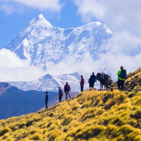
Some treks are more about their trail than their summit; the Bagini Glacier and Changabang Base Camp trek is one such trek. This trek will offer you altitudes as high as 15,900 ft (Bagini Glacier) and a glimpse of peaks as high as Mt. Nanda Devi (7,817 m). One might think that the view of Mt. Nanda Devi is probably the trek's end goal, but that’s not the case. The view of this peak catches you from Pipalkoti to Joshimath, and leaves you to your own devices thereafter.
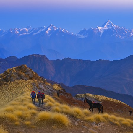
The Bagini Glacier trek is perfect for testing your endurance in the Himalayan ranges. You move higher, and the oxygen becomes scarce, slowly, but surely. Plenty of water sources throughout the trek, with ascents followed by level walks, contribute to this trek being of moderate difficulty. Like every trek in the Uttarakhand Himalayas, this one also flaunts unparalleled nature and is rich in cultural and demographical significance. The Ruing and Dronagiri villages on the trail loudly recount the stories of this region’s past and present.
Bagini Glacier’s presence is felt throughout the trek thanks to the crinkling of water coming from the Bagini River (locally called Bagini Nala) flowing along the trek. While the end goal is to reach the Changabang Basecamp and have a look at Mt. Changabang (6,864 m), Mt. Kalanka (6,931 m), Mt. Saf Minal (6,911 m), and Mt. Rishi (6,992 m), this doesn’t diminish the existence of other peaks on the trek. The other peaks being Mt. Haathi (6,727 m), Nanda Ghunti peak (6,309 m), Mt. Nanda Devi (7,817 m), Ghodi Parvat (6,708 m), Dronagiri East peak (7,006 m), Garur peak (6,268 m), Mt. Hardeol (7,151 m), and Mt. Trishul (7,120 m).
The trek’s religious significance is in the Dronagiri valley, and people who deny prayers to Lord Hanuman. They are angry at him for taking Sanjeevni Booti (Selaginella bryopetris) from the valley without asking, and blame him for committing theft. The folklore included, the Bagini Glacier and Changabang Basecamp trek offers experiences of forest cover (a mix of oak, maple, pine, and deodar trees), Himalayan musk deer, snow patches, and snowfall depending on the season.
The trek is beginner-friendly, but not without a guide and good physical health. Hour-long drives and trekking on the same day might even be one of the unique features of this trek. So, if you are up for the challenge and want this accomplishment on your trekker portfolio, the Bagini Glacier and Changabang Base Camp trek is the right trek for you!
Rishikesh Altitude: 1,120 ft (340 m)
Pipalkoti Altitude: 4,200 ft (1,280 m)
Altitude Gain: 3,080 ft (939 m)
Travel Distance: 210 km
Travel Hours: 9-10 hrs (approx.)
Today begins with a 210 km journey to Pipalkoti, from where, a little drive later, you are at Jumma, where you start your trek. On your way to Pipalkoti, you will rarely be bored as the winding roads bring something new at every turn. The natural beauty aside, the religious sites and rivers on your way fill your sight with wonders.
The Ganges River is your companion from Rishikesh to Devprayag (the confluence of Bhagirathi and Alakhnanda rivers), where it changes hands with the Alakhnanda River. Moving forward on the Badrinath road, you are soon at Rudraprayag Sangam (the confluence of Mandakini and Alakhnanda rivers). Eventually, on your way to today’s final stop, you reach Karnaprayag Sangam (confluence of Pindar and Alakhnanda rivers).
The route takes you through various popular places, including Gaucher, Srinagar, Nagarsu, Dhari, Shivpuri, and Chamoli. The gurgling stream and the musk scent of pine and deodar trees lining the roads make for a gentle drive. Soon enough, you are at Pipalkoti, with towering hills and a distant view of the Garhwal Himalayas welcome you.
Jumma Altitude: 9,000 ft (2,743 m)
Ruing Village Altitude: 9,300 ft (2,835 m)
Altitude Gain: 5,100 ft (1,554 m)
Travel Distance (camp at Ruing): 85 km (drive) + 3 km (trek) = 88 km (approx.)
Travel Hours (camp at Ruing): 2.5 hr (drive) + 3 hrs (trek) = 5.5 hrs (approx.)
Travel Distance (camp at the meadow): 85 km (drive) + 3 km (trek) + 3 km (trek) = 91 km (approx.)
Travel Hours (camp at the meadow): 2.5 hr (drive) + 3 hrs (trek) + 2.5 hrs = 8 hrs (approx.)
Today’s travel and steep slopes will get you ready for the coming trails in this trek. The morning is slow as the day doesn’t have much to do, if everything goes favourably at Ruing Village and we are allowed to set camps there or stay at the Panchayat Ghar. In case we are denied access to camps and a stay at Ruing village, we are to trek to a meadow 2-3 km further from the village, which is also a great place to camp.
The day starts with breakfast at Pipalkoti and boarding vehicles (preferably jeeps) to reach Jumma. On your way to Jumma, you pass through other famously known places, such as Joshimath and Tapovan. Joshimath has long acted as a centre for various destinations, including Badrinath, the Valley of Flowers trek, and the Hemkund Sahib trek. Tapovan is also of importance as it's the last stop for food, no hotels further on the way to Jumma.
If the drive to Tapovan wasn’t enough treat of nature for you, then towering mountains and the Dhauli Ganga river will never leave your sight after Tapovan. After an hour-long drive from Pipalkoti to Joshimath, you are an hour and a half away from reaching Jumma. The 2.5-hour drive to Jumma takes you to cross an iron bridge, and soon after, the trail to Ruing village begins. Once you are past the forest cover, you are at Ruing, which has a surprising mix of old and new house infrastructures. The people here migrate to lower altitude areas during extreme winters, so you might find locks guarding their doors during winter.
The village is best suited to set a camp and rest for the night, the chilly wind is a given, seeing its closeness to the Tibetan border. For the curious, the road leading up to Nithi Pass lies bare in front of the Ruing village. The mix of cedar, oak, and deodar trees makes Ruing the perfect Himalayan hamlet. In case the stay at Ruing isn’t possible, the trek to the meadow uphill from Ruing and a camp there is best for stargazing and trek timings for tomorrow.
Dronagiri Altitude: 11,600 ft (3,536 m)
Altitude Gain: 2,300 ft (701 m)
Travel Distance (camped at Ruing): 7.5 km
Travel Hours (camped at Ruing): 8 hrs (approx.)
Travel Distance (camped at the meadow): 4.5 km
Travel Hours (camped at the meadow): 4 hrs (approx.)
The way from Ruing to Dronagiri is a little complicated, so let’s break it down firsthand.
Got permission to stay and camp at Ruing:
Ruing→The Meadow→Dronagiri (7.5 km)
Didn’t get permission to stay and camp at Ruing:
The Meadow→Dronagiri (4.5)
As you start your track today, the trail is much like any other Himalayan trek and goes through forests for the ⅔ rd part of it. The rest (⅓ rd) consists of a popular and fragile landslide zone with a stream at the end of it, and then a 1 km steep climb to Dronagiri, after which you trek another 1 km uphill with a moderate ascent. The last 1 km is completed with Dronagiri village within your sight.
The way to Dronagiri village is cemented, and you also see the power lines going to the village; still, there are not enough facilities for the villagers to stay there in winter. The villagers migrate to low altitudes to escape the freezing cold; therefore, if you do the Bagini glacier and Changbang basecamp in winter, you will find locks on the otherwise welcoming homes.
The forest cover that you cross right after Ruing is rich in deodar, cedar, and has the occasional pines, maple, and birch trees too. Today’s trek, for the most part, is a mix of gradual ascents followed by level walks. This pattern only ends as you reach the landslide zone with a narrow path and little to no chance of losing focus. The gurgling of streams and the Bagini River (also locally called Bagini Nala) flowing in the valley below the trail keep you company.
The other attractions for today are the views of Mt. Haathi (22,070 ft) and Mt. Ghodi or Gauri Parvat (22,008 ft). Unlike its name suggests, do not expect to see the Dronagiri peak from the Dronagiri Village, but you will get to see the old Garhwali houses made of mud, wood, and stone. After dinner, you can choose to rest for the day or check out the stars on a clear night sky. A bit of luck mixed with strength goes a long way.
Longatulli Altitude: 13,000 ft (3,962 m)
Altitude Gain: 1,400 ft (427 m)
Travel Distance: 6 km
Travel Hours: 8 hrs (approx.)
Mimicking most of the days on this trek, today also throws at you a mixed trail with moderate ascent and descent at places. The day begins with breakfast at Dronagiri, offering a view of Haathi and Ghodi Parvat (peaks). Some days can be cloudy and obstruct a clear view of the Himalayan ranges, but it’s still worth your while.
Dronagiri village might not have a view of Mt. Dronagiri, but is popularly known for being en route to Dronagiri Basecamp, and also having a way that splits to reach Nandikund too. Then there’s always the route uphill from the valley that will take you closer to Longatulli (today’s campsite). After a little trek uphill from Dronagiri and then downhill for a while, you reach a point where you get the first glimpse of Mt. Rishi (beside Bagini Glacier) and Dronagiri East peak (23,182 ft).
Look at the other side of the valley, and you see Longatulli at a distance. Gauging the path to the campsite becomes easy from here on. The entire Dronagiri valley now opens up to your eyes, and you see the Bagini Glacier at the end of the valley. Other considerable peaks visible from here are Mt. Hardeol (23,461 ft) and Trishuli Parvat (23,360 ft). Following the stone and gravel trail down, you reach the cemented bridge over Bagini Nala, and cross it to access the other end of the valley.
An uphill climb afterwards takes you to show a birdseye view of the valley, and depending on the season, the valley appears green, brown, red, and orange. An hour after crossing the bridge, you are at a level field locally called Sem Kharak, which is a kilometer away from Longatulli.
The location marker and main attraction of Longatulli campsite is a tin shed (a perfect safe spot for any extreme weather conditions). This campsite sees constant snowfall during the winter, making it hard to stay warm. The tin shed has two distinctive features: one is that the shed’s door opens to a magnificent view of Mt. Rishi, and the other is a huge rock guarding it from behind.
Water is never scarce at this campsite as the river flows right beside it, no scarcity of water till Bagini Basecamp, which makes the Bagini glacier and Changabang base camp trek a unique trek among others. All that’s left for the day is for you to dine, rest, and restore energy for tomorrow.
Bagini Basecamp Altitude: 15,000 ft (4,572 m)
Altitude Gain: 2,000 ft (610 m)
Travel Distance: 4.5 km
Travel Hours: 6.5 hrs (approx.)
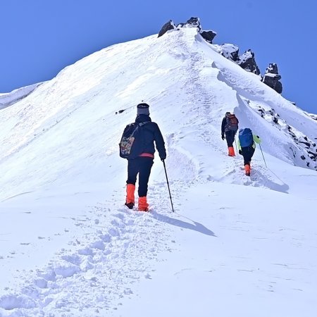
The trail gets tougher starting today; it’s a combination of moraines, boulders, and steep ascents at different altitudes. As far as the most challenging part of today’s trek is concerned, the trail’s steepness takes a backseat, and the lack of oxygen at higher altitudes takes priority. So, you will feel tired, but not as much because of the trail as it is because of the low oxygen concentration in the air. The only advice for today’s trek is to follow instructions and not make it a race. Walk with a slow and consistent pace.
The trail to Bagini Basecamp (also called Bengali Basecamp) goes right along the Bagini River (originating from Bagini glacier) and follows you till the campsite too. If the weather is ideal and the temperatures are less freezing, the river water becomes your water source at the Bagini Basecamp. Our team will decide where to camp depending on the water availability, as the higher you go, the lower the probability of accessing running water.
With each kilometer on the trail, the path gets rockier than before, and the Himalayan mountains start to appear far more huge than they look from Dronagiri or Longatulli. The river banks appear very broad, and you’ll realise that the Bagini river might be more than a tiny stream and destructive during monsoon.
The uphill climb comes bearing rewards such as Mt. Saf Minal (22,674 m), which starts to show besides the Rishi Parvat. With the clear blue sky in the background, these two peaks are a sight to capture for a lifetime. The trail mixes clear routes and huge rocks, and you walk on level ground and also step on the stones to get through the tougher patches. The route is difficult and takes around an hour and a half to cover a kilometer from Longatulli to Bagini Basecamp.
Constant efforts bring you to a point where Rishi Parvat and Mt. Saf Minal will stand tall right in front of you. It is also where the Bagini Glacier starts on your right-hand side. To avoid frozen waters, the camps are set on a level field here. It is now your time to appreciate Mt. Saf Minal, which was 1st summited in 1975 by a Japanese team and then in 2004 by an American and British team.
Bagini Glacier Altitude: 15,900 ft (4,846 m)
Changabang Basecamp Altitude: 14,800 ft (4,512 m)
Altitude Gain/Loss: 900 ft (274 m)
Travel Distance: 3 km (trek) + 3 km (trek) = 9 km (approx.)
Travel Hours: 6 hrs (approx.)
The sunrise from Changabang Basecamp is the goal today, and it calls for you to wake up early. The trek starts early; therefore, the temperature is still below 0℃ (sunrise is far from hitting the trail you are walking), and you have little light to navigate the trek. The best thing to do is to follow your guide for this trek, as the crevasses are hard to detect and much easier to fall into. Walk very carefully, slipping on snow at this altitude might cause you a little more than just a mistake.
Keep your sunglasses handy if sightseeing at the Bagini Glacier is your goal. They will help you avoid headaches due to light reflected from the white snow as the sun comes up. While trekking towards the Bagini Advanced Basecamp (also called Garur Basecamp) and further, you feel like walking on a majestic white desert. You should wear layers, as no matter the sun's warmth, it is no match for the chilly wind.
The way up isn’t monotonous, and peaks like Mt. Kalanka (to the right of Mt. Saf Minal) start to show. Soon after, Mt Changabang (22,520 ft) follows, which is to the right of Mt. Kalanka (22,740 ft). Once at Changabang Basecamp, you get a more prominent view of these peaks, including Mt. Rishi, mt. Saf Minal, Mt. Kalanka, Mt. Changabang, Mt. Trishuli, Hardeol peak, Dronagiri East, and Garur peak (50,564 ft).
Our trek route looks somewhat like this:
Bagini BC (Basecamp) → Bagini Advanced Basecamp→ Changbang Basecamp
This summit is enough for many, but this isn’t the highest point, and if time allows, you can still climb 200 m further for the next 45 minutes and summit this trek. There, look down and your eyes are graced with a green glacial triangular lake called Rishikund (14,337 ft). Here, the Rishi Parvat stands tall, and the lake appears right at its roots. If you try to take a look behind you, opposite of the Rishi Parvat, you see there’s Mt. Haathi (your constant companion for most of this trek).
After spending a few hours at Changabang Basecamp, it's time to trace the 3 km route back and rest at the Bagini Basecamp campsite.
Dronagiri Altitude: 11,600 ft (3,536 m)
Altitude Loss: 3,400 ft (1,036 m)
Travel Distance: 12 km (approx.)
Travel Hours: 10 hrs (approx.)
You wake up and have your breakfast at Bagini Base Camp, which has a lot to offer, like the views of Mt. Saf Minal, Rishi Peak, and the beginning of Bagini Glacier. The sunrays take their sweet time to hit this area, and it's freezing during winter. The only ray of hope is the mountain tops of Rishi Parvat (peak) and Mt. Saf Minal that are shimmering with the sun’s rays.
As you move downhill, the first point you recognise, after crossing the morraines, is the level field of Longatulli, the tin shed and the river flowing beside it. The Rishi Pravat accompanies you here too, while Mt. Saf Minal is out of sight. Moving forward, you cross the familiar valley, right after the cemented bridge, which takes you from one side of the valley to the other.
The valley and the Himalayan belt towards the Dronagiri Village have become the focus now. You can either look at the valley flaunting its beauty in red, yellow, pink, or green (depending on the season) or the towering yet humble Mt. Haathi, along with the Gauri Parwat (peak). Hereon, somewhat distant, but always within sight, Dronagiri village acts as your compass, and finally, the rest stop as you rejuvenate from 10 hrs of tiresome walking. We set up camps and have dinner here for today, or maybe with villagers, if they’re feeling generous.
Pipalkoti Altitude: 4,200 ft (1,280 m)
Ruing Altitude: 9,300 ft (2,835 m)
Altitude Loss: 7,400 ft (2,255 m)
Travel Distance: 10.5 km (trek) + 85 km (drive) = 95.5 km (approx)
Travel Hours: 8 hrs (trek) + 3 hrs (drive) = 11hrs (approx.)
The day is comparatively hectic today, especially if time is the context. We start early to cover the entirety of 95.5 km (trek + drive) within the 11 hr timespan. After a healthy and hot breakfast at Dronagiri village, with the sunrise painting the Hathi Parvat red and yellow, you get ready to trek downhill.
After tracing the same cemented trek you came up from, you reach the much-feared landslide zone on this trail. Take the guide’s advice and walk straight ahead, keep away from the edges, and avoid zoning into the scenery. This patch in the trail is narrow and requires your attention more than the muddy trail that’ll soon follow.
Following the same mix of descents and level walks, you’ll soon find yourself at Ruing village’s cemented trail. Passing the old and new houses in the village, you are reminded of your trek uphill. Soon we’re on the off-trail motorable road from Ruing to Jumma (3km). Here, you will either board vehicles to Pipalkoti or take a 3 km stroll to the iron bridge at Jumma, and then board your vehicles to Pipalkoti, finally bidding farewell to the Niti Highway.
At Pipalkoti, take your time to relax, reminisce, and unwind the good and bads of the journey with your fellow trekkers and our team. Your adventure trek to Bagini Glacier and Changabang Base Camp is nearing its end, just one day, and you’ll be home.
Rishikesh Altitude: 1,120 ft (340 m)
Altitude Loss: 3,080 ft (939 m)
Travel Distance: 210 km (approx.)
Travel Hours: 9-10 hrs (approx.)
An early morning today brings back memories of the first day of the Bagini Glacier and Changbang Base Camp. The experience is richer as you cherish the memories of the entire trek while on your way back to Rishikesh. The winding roads, the towering peaks, the faint smell of nature, and the snow-covered peaks of the Garhwal Himalayas are all a little sweeter today.
Rudraprayag, Karnaprayag, and Devprayag shine as always, but you also notice Nandaprayag while crossing the Nandakini River near the Nandaprayag Bridge. Birahi Ganga makes itself obvious with its gurgling water as your taxi crosses the Birahi Ganga Bridge.
Other noticeable and stop-worthy points on the way include a mix of religion and nature. Some popular names include The Hilary Waterfall, Prachin Hanuman Mandir, Shree Kalpeshwar Mahadev Mandir, Koteshwar Mandir, etc.
Accommodation
Meals (Vegetarian only )
Nutritious meals from Day 1's dinner to last day's breakfast, following the itinerary schedule.
Expert Support
First Aid Preparedness
Fully equipped medical kit including a stretcher, oxygen cylinder, blood pressure monitor, oximeter, and stethoscope to ensure safety throughout the journey.
Storage Facilities :- A secure room at the base camp to store additional luggage not needed during the trek.
Permits and Entry Fees :- Coverage of all necessary permits and entry fees, in line with standard charges for Indian nationals.
Transportation :- A round-trip transport from the pick-up point and back at the same point as a part of the itinerary.
Trek Equipment
Insurance :- Personal insurance is mandatory and not included in the package.
Personal Expenses :- Any expenses of a personal nature, including shopping, snacks, hiring a mule or porter for carrying your belongings, or acquiring personal equipment.
Emergency Costs :- Expenses arising from emergency evacuations, hospitalization, or any medical treatments required.
Unspecified Services :- Any services or items not explicitly mentioned under the "INCLUSIONS" section.
Food Costs :- We will not cover any food costs during your transit to and from the base village.
Trekking is not only about enjoying the change of scenery but also about being responsible. Our (Trekking Compass) responsibility is to provide you with an opportunity for a safe trek. But, how do we do that? We do that when you fulfill your end of the responsibility and are honest with us. To keep you safe we need to be sure there isn’t any inherent threat to your being.
Treks are at higher altitudes and it becomes difficult, almost impossible to provide you with immediate medical assistance. Therefore, we cannot help you if you don’t help us. Trekking is only one of the things you can do, but there are plenty of other things to do too. Don’t risk your life for the thrill.
To approach a trek with utmost safety, we want you to submit the following documents:
Personal Confirmation Statement (Compulsory for anyone over 18 years)
You are participating in a trek at high altitudes and it comes with its own sets of risks. This Personal Confirmation Statement will make sure that you understand all the risks you're buying into. Trekking Compass wants you to confirm your complete understanding of these risks so that you come prepared for any mental or physical challenges ahead.
This statement is also a declaration from you that, "All the information I have provided, including medical conditions, is true. If found false under any circumstances, I will be held accountable and it has nothing to do with Trekking Compass."
We have the utmost empathy for you and will do our best to help wherever possible, but only after assessing your readiness and safety for the trek. This is how our team will adequately prepare for whatever risks we might face during the journey. Concerning individuals are requested to thoroughly cross-check the requirements and only then sign the document.
Parent/Guardian Approval Statement (Compulsory for anyone below 18 years)
For participants under 18 years of age, the Parent/Guardian Approval Statement is essential to confirm that a legal guardian understands and consents to the participation in the trek. Once we have this document, we are affirmed that the parent or guardian is fully aware of the risks involved in trekking at high altitudes and is consenting to their child's participation.
No underage (below 18+) children are welcome on the trek without their parent's consent. Submission of this document reassures us that parents are approving that their child meets the health and fitness requirements for the trek, after a thorough examination.
This legal confirmation holds the parent liable for any discrepancies, freeing Trekking Compass from any liabilities for the same. Parents are requested to thoroughly cross-check the requirements and only then sign the document.
Medical Liability Waiver
The Medical Liability Waiver makes sure participants acknowledge the health risks associated with trekking at high altitudes. Common ailments during treks include altitude sickness, dehydration, muscle cramps, hypothermia, and fatigue, all of which can significantly affect your trekking experience. Additionally, weather changes and the physical demands of the terrain may exacerbate pre-existing conditions.
If you have pre-existing medical conditions such as asthma, diabetes, or heart issues, it’s vital to inform us and carry your necessary medications. Trekking Compass cannot provide immediate medical assistance in remote areas, so having the essential medications, such as inhalers, insulin, or any other prescriptions, is crucial for your safety during the trek.
By signing this waiver, you confirm that you are in good health and have taken the necessary precautions. You acknowledge these risks and agree not to hold Trekking Compass liable for any medical issues or accidents that may arise during the trek.
For any further doubts about anything mentioned above, below is our contact information:
OFFICE ADDRESS: Lane No. 4 Krishna Vihar Mohkampur, Dehradun, Uttarakhand, 248005
PHONE NUMBER: +91 7055048487, 7055048488
EMAIL ADDRESS: info@trekkingcompass.com
HOW TO REACH ? (RISHIKESH)
Note: Keep a buffer day in your getaway in addition to the total days in the itinerary. This day will come in handy in case of any political unrest, landslides, or rains. If not, you can use the extra day to get to know Rishikesh. This means that for an itinerary ending on the 15th of a month, book your return tickets for the 16th.
What are the different ways to reach Rishikesh?
On the Bagini Glacier and Changabang Base Camp , our first long-day trip is from Rishikesh to Pipalkoti (215 km). Therefore, trekkers need to reach Rishikesh to start the trek. The first move to reach Rishikesh for any trekker is to reach either Dehradun or Delhi. Later, every trekker can choose their choice of transport. The available transports for Rishikesh are:
Medium: BUS
A Friendly Note: You should travel by government buses instead of private ones because the private buses tend to take more time than expected. To avoid missing the pick-up time, try traveling by government bus, wherever possible.
Medium: TRAIN
Medium: FLIGHT
Fly Directly to Dehradun and then to Rishikesh: To fly directly at Jolly Grant Airport Dehradun, there are multiple flights from metropolitan cities. The companies that facilitate these flights are:
Fly to Delhi then take a bus or train to Rishikesh: It’s very easy to fly to Delhi from anywhere in the country and take a bus to Rishikesh. You will find a detailed description of buses in the BUS section. The companies that facilitate these flights to Delhi are:
Note: Make sure that the mode of transport you choose should bring you to Rishikesh a day before Day 1, i.e., Day 0. You can fly to Delhi and Dehradun from Mumbai, Kolkata, Bengaluru, Chennai, Hyderabad, Pune, and to Dehradun from Delhi too.
What happens on the drop-off day
Here are the points that explain your drop-off:
Special Case: What if you miss our pick-up?
You shouldn't panic and follow one of the below-mentioned ways to Lohanjung:
| Backpack with rain cover / Trolley Bag | Main bag for gear. |
| Day pack with rain cover (20 - 30 L) | For day essentials, if the main pack is off-loaded. |
| Walking stick | Recommended (at least one). |
| Water bottle/ Hydration pack | 2 bottles (1L each) or 1 hydration pack and 1 bottle. |
| Snacks | Energy bars, dry fruits, ORS/electrolytes. |
| Personal Medical Kit | As prescribed by your doctor. |
| T-shirts (Synthetic, quick-dry) | 2 full-sleeve, 2 half-sleeve. |
| Fleece T-shirts | 2 pieces. |
| Wind-stopper / Fleece jacket (upper) | 1 piece. |
| Windproof jacket | 1 piece |
| Down feather / Hollow jacket | 1 piece |
| Thermal innerwear (Upper & Lower) | 1 set. |
| Trekking pants (Synthetic, quick-dry) | 3 pairs. |
| Wind-stopper / Fleece pants (lower) | 1 pair. |
| Waterproof gloves | Not required. |
| Fleece / Woolen gloves | 1 pair. |
| Poncho / Waterproof jacket and pants | 1 set. |
| Head torch / Hand torch | 1 piece. |
| Sun cap | Required. |
| Woolen cap | 1 piece. |
| Balaclava | 1 piece. |
| Buff/ Neck gaiters | 1 synthetic, 1 woolen. |
| Sunglasses | UV protection with side covers (for spectacle users: contacts or photochromatic lenses). |
| Trekking shoes (waterproof, high ankle, good grip) | 1 pair. |
| Floaters / Flip-flops | 1 pair. |
| Cotton socks | 4 pairs. |
| Woolen socks | 2 pair. |
| Sunscreen | 1 piece. |
| Moisturizer | 1 piece. |
| Lip balm/ Chap-stick | 1 piece. |
| Toothbrush and toothbrush | 1 set. |
| Toilet paper and wipes | 1 pack each. |
| Soap/ Hand sanitizer | 1 piece. |
| Quick-dry towel | 1 piece. |
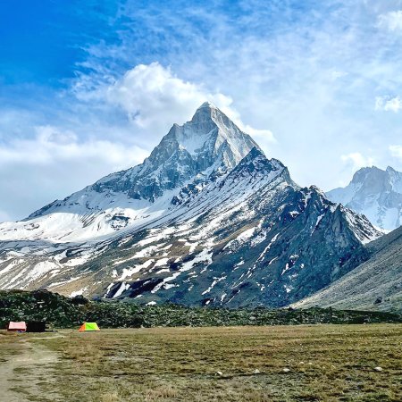
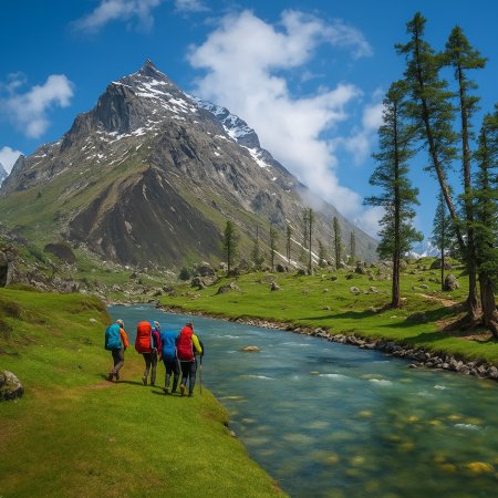
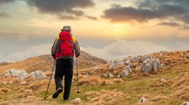
The Bagini Glacier Trek is a high-altitude trek in Uttarakhand’s Garhwal Himalayas, taking you deep into the Nanda Devi Biosphere region. This trek leads trekkers through ancient Himalayan villages, dense forests, alpine meadows, and finally into the glacier basin surrounded by snow-clad peaks. The highlight is reaching Changabang Base Camp, where you stand face-to-face with the legendary Changabang Peak (6,864 m), along with views of Kalanka, Dunagiri, Hathi Parbat, and Trishul. Unlike popular treks such as Kedarkantha or Brahmatal, Bagini Glacier remains less commercialized, which means you experience the Himalayas in their raw, untouched form. This trek combines remote adventure, glacier exploration, and cultural immersion, making it ideal for serious trekkers.
The best time to trek to Bagini Glacier and Changabang Base Camp is in the summer months (May–June) and post-monsoon season (September–October). During May and June, the meadows come alive with wildflowers, streams flow freely, and the weather remains pleasant, making it easier to walk through high-altitude terrain. Post-monsoon months bring crisp skies, breathtaking mountain visibility, and a snow-capped Himalayan backdrop, though the nights get colder. Winters (November–March) are not recommended due to heavy snowfall and closed trails, while the monsoon season (July–August) brings landslides, overflowing rivers, and slippery moraine routes, which can be dangerous.
This trek is considered moderate to difficult. While the first few days through villages and meadows are relatively gentle, the difficulty increases once you enter moraine zones and approach the glacier. The section leading to Changabang Base Camp involves walking over boulders, navigating scree slopes, and handling unpredictable weather conditions at high altitude. Unlike easier treks such as Brahmatal or Pindari Glacier, Bagini Glacier demands physical stamina, mental endurance, and prior experience of at least one Himalayan trek above 3,500 m. It is not recommended for absolute beginners but is perfect for trekkers ready to take the next step into remote glacier trekking.
The Bagini Glacier Trek covers about 53 km (depending on campsite selections and side hikes) and usually takes 8–9 days to complete. The journey begins from Joshimath (the hub of Garhwal treks) and proceeds to Jumma village, the roadhead. From there, trekkers move through villages like Ruing and Dronagiri before reaching Bagini Base Camp. The trek typically includes acclimatization days, steady ascents through forests and meadows, and long stretches of glacier moraine walking. Daily trekking hours range from 5–8, making it moderately strenuous.
The highest point of the trek is Changabang Base Camp at around 4,610 m (15,900 ft). Standing here, you get close-up views of Changabang Peak, Kalanka, Trishul, Dunagiri, and Hathi Parbat. Unlike treks like Kedarkantha or Brahmatal, which stay below 4,000 m, Bagini Glacier crosses the line where altitude becomes a major factor. At this elevation, weather conditions change rapidly, and trekkers must be well-acclimatized to avoid altitude sickness.
Yes. The Bagini Glacier Trek is not for complete beginners. It involves glacier terrain, moraine fields, and remote conditions with limited facilities. Ideally, trekkers should have completed at least one Himalayan trek above 3,500 m (such as Roopkund, Hampta Pass, or Rupin Pass) before attempting Bagini Glacier. Experience in camping, walking long hours with a backpack, and handling altitude is essential.
Trekkers need a high level of physical fitness. You should be able to jog 5 km in 30–35 minutes, carry a 10–12 kg backpack comfortably, and walk uphill for 6–8 hours a day. Pre-trek preparation should include cardio exercises (running, cycling, swimming), leg strengthening (squats, lunges), and stair climbs with weight. Since the trek involves challenging sections, strong endurance and stamina are crucial for a safe and enjoyable experience.
Accommodation on this trek is basic and adventurous. In Pipalkoti and Jumma (base villages), trekkers can find homestays and guesthouses with basic amenities. Once the trek begins, all accommodation is in tented campsites. Camps are usually set in scenic locations near alpine meadows, riversides, or glacier moraines. Tents are shared (2–3 trekkers), equipped with sleeping bags and mats. Unlike treks in more commercialized regions, Bagini has no tea houses or fixed shelters, so trekkers must rely entirely on camp arrangements.
Yes, permits are required because Bagini Glacier lies within the Nanda Devi Biosphere Reserve buffer zone. The trek also passes near villages that require forest and gram panchayat permissions. These permits are typically arranged by us, I.e Trekking Compass. Carrying a valid government-issued ID proof is mandatory for obtaining permissions.
The trek begins at Jumma village, which is about 45 km from Joshimath. Joshimath itself is well-connected by road — it takes 9–10 hours by vehicle from Haridwar or Rishikesh (270 km). Shared jeeps or private taxis are available. Joshimath also serves as a hub for treks like Kuari Pass, Valley of Flowers, and Nanda Devi. From Joshimath, trekkers drive to Jumma, and the actual trekking begins from there.
Yes. Since the trek crosses 4,500 m, trekkers are at risk of Acute Mountain Sickness (AMS). Symptoms include headache, nausea, dizziness, and shortness of breath. To minimize risks, trekkers should ascend gradually, stay hydrated, avoid alcohol, and report any discomfort to trek leaders immediately. Carrying Diamox (after consulting a doctor) can help. Guides usually carry oxygen cylinders and first aid for emergencies.
Yes, when done with an experienced trekking company. The trek is remote and challenging but generally safe if you follow acclimatization protocols and listen to your trek leader. Solo trekking is not recommended due to the remoteness, absence of marked trails in glacier zones, and lack of facilities.
Our trek leaders are trained in first aid and equipped with oxygen cylinders and stretchers. The nearest medical facilities are available at Sankri, and evacuation arrangements are made if required. Travel insurance covering trekking is strongly advised.
Handpicked routes with strong scenery, reliable pacing, and a premium featured block that still stands apart from the rest of the archive page.
Crafted routes, reliable execution, and a trekking experience that feels premium from planning to summit.
 Safety
Route checks, first-aid readiness, and trained leaders to keep every step confident.
 Routes
Better pacing, better camps, and real acclimatization designed for experience, not speed.
 Groups
Less crowd, more care so you enjoy the trek, not just finish it.
 Trust
Trust
Clear inclusions, no hidden surprises, and real human support on WhatsApp.