15% Off

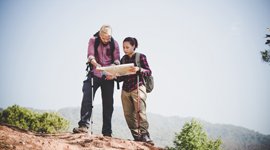
Route Length

Max Altitude

Trek Duration

Trek Difficulty

Base Camp Area

Pickup Point
10+ Years Age
First timer can apply, previous trekking experience is more appreciated.
Cover 5 km of distance in 30 minutes without a stress.
+917055048487, +917055048488
trekkingcompass@gmail.com
The Pindari Glacier trek leads you to the very source of the Pindar River, a major tributary of the Alaknanda. The two rivers meet at Karnaprayag, uniting waters from Kumaon’s Bageshwar and Garhwal’s Chamoli, a true confluence of landscapes and cultures.
For many, the trek builds up to one unforgettable sight: the full view of the glacier’s sweeping icefall. For others, it’s a deeply personal journey, shaped by moments only they can claim.
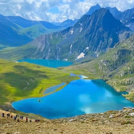
At the Zero Point (12,200 ft), you are undoubtedly amazed by the 3.5 km-long and 1.7 km-wide colossal glacier in front of your eyes. You have stories to build around the pink rhododendrons, the dense forest cover, and in the flash of a Himalayan Monal’s wings, or in the regret of missing it.
Heroic moments come from crossing ice and makeshift bridges, tackling rushing streams, spiderwalls, scissor bends, and landslide zones. Himalayan Ibex, grazing sheep, and horses only add more character to the trail. It’s a full meal course for any trekker, yet it asks for a little, making it just as suitable for families.
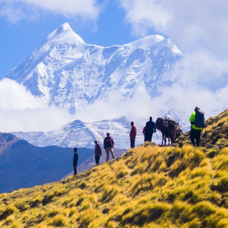
The giveaways don’t stop there; the skyline is crowned with towering peaks: Maiktoli (22,320 ft), Nanda Khat, Nanda Devi East, Panwali Dwar, Balijuri (19,436 ft), Changuch, and Nanda Kot. Along the way, our experienced local guides share the history behind landmarks like the suspension bridge and the government rest house at Dwali, both built during the British era.
The trail itself is a living reminder of the centuries-old trade route to Tibet through the Milam and Pindar valleys. And in its legacy lies the 1830 exploration by G.W. Traill, the first deputy commissioner of Kumaon, who mapped the shortest route to Martoli village in the Milam Valley.
Six significant landslide zones mark the route. These scars of the 2013 floods stand as quiet reminders of nature’s power and the trail’s resilience. Everything about this journey makes you understand why locals call it the Soul of Kumaon.
When you think of the Pindari Glacier trek in Uttarakhand, think history, geography, and experience woven into one. Seasoned or new, every responsible trekker can find their place on this trail in the Kumaon Himalayas. Are you one? Then get on board!
Kathgodam Altitude: 1,490 ft (454 m)
Khati Village Altitude: 7,350 ft (2,240 m)
Altitude Gain: 5,860 ft (1,786 m)
Travel Distance: 220 km (approx.)
Travel Hours: 11 hrs (approx.)
Today takes you on an 11-hour-long drive. You go from Kathgodam, which has the last train station in the Kumaon region, to Khati village, the last inhabited village towards that side of the Himalayas. The first step in reaching Khati village is to reach Bhowali. You can take two routes based on your convenience, one takes you through Jeolikote (35 km), and the other through Bhimtal (30 km).
A little further on the hilly roads from Bhowali, Kainchi Dham comes into view. You can pay your regards, but seeing the time crunch, we will hardly make a stop. From Kainchi, we reach Khairna and then Almora. Before entering the primary market in Almora, you come to a crossroads. One (left-hand side) takes you through the market to Takula and then to Bageshwar, while the other takes a different route, where you go to Kosi, then Someshwar, and eventually Bageshwar.
At 40 km from Almora, you reach Someshwar, which is popular for the Someshwar Mahadev temple there. Just 14 km from here is Kausani, a popular hill station and tourist attraction, and then you cross Garud to reach Bageshwar. Bageshwar takes its name from a folklore that Lord Shiva appeared here in the form of a bagh (Uttarakhand leopard). This place finds its value in the valley it is in, at the sangam (confluence) of the Saryu and Gomati rivers, and the Baghnath Dham.
After Bageshwar, the route looks like this: Bageshwar→ Kapkot→ Bharaadi→ Dhakudi→ Khati. You will know that you have reached Khati village as a gate that reads, “I ♡ Pindari. Welcome to Khati,” greets you. You rest for the day at a guesthouse or homestay in Khati, have dinner, and be ready for the trek the next day.
Dwali Altitude: 8,580 ft (2,615 m)
Altitude Gain: 1,230 ft (375 m)
Trek Distance: 13 km
Travel Hours: 8 hrs (max.)
Your attraction for the day is a 13 km trek to Dwali, a small outcrop located at the confluence of the Pindar and Kafni rivers. The story behind and the aftermath of today’s trek is the 2013 flood that struck the Pindar and Saryu valleys. Since then, the original trail to Dwali has 6 landslide zones. These zones require trekkers to trek downhill from the ridge and walk beside the riverbank. The walk continues till they can walk back to the same ridge that they earlier descended.
From the 6 landslide zones, the most difficult detour is on the 5th one, where you navigate dense vegetation alongside 4-scissor bends. Here, the Trekking Compass team’s expertise pitches in, making it easier to navigate.
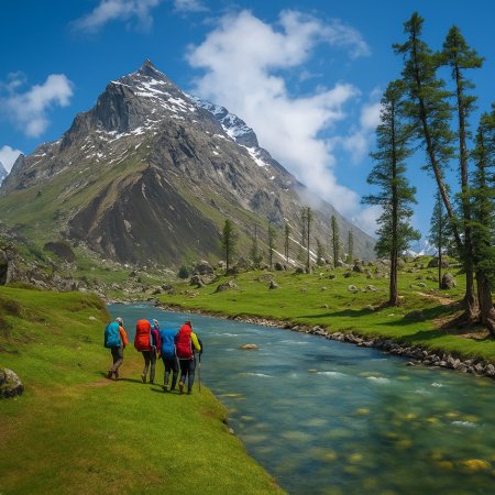
Other than the technicalities, the trail has a lot more to offer, wherein the Pindar River accompanies you to Dwali, always gurgling and roaring on your right-hand side. This, along with the quaint peace of the hills, makes the trail more than worthy of your 8-hour-long effort.
The stone-laden and surprisingly well-maintained trail from Khati takes you on a 2 km mild ascent. At a stop 20 minutes into the trek, you get a bird's-eye view of Khati village. Soon after, you arrive at a stream (the first water point of the day), then you cross the Pindar River on a suspension bridge, which speaks volumes about its own history. 3-4 km further, you cross another iron bridge and encounter a dhaba (small restaurant) run by a local elder.
The route is rich in tree species native to the Himalayan areas, like a mix of Banj trees (brown oak), Aiyaar trees (Tree of Heaven), and Ringal plants (dwarf bamboo). These species, combined with waterfalls, brooks, and log bridges, hype up the entire experience of this trail.
After the forest cover gets scarce, you are 1 or 2 km away from Dwali and can see it from afar. The last step is to cross both the Pindar and the Kafni rivers on the makeshift bridges to reach Dwali. This place has an old British building, currently acting as the government rest house, and a handful of guesthouses operated by locals. The day ends with exhaustion, satisfaction, and a warm meal with a good night’s sleep.
Note: If you’re lucky, you can catch sight of a bird, the White Capped Redstart.
Phurkiya Altitude: 10,510 ft (3,203 m)
Altitude Gain/Loss: 1,930 ft (588 m)
Trek Distance: 5 km (approx.)
Travel Hours: 3-4 hrs (approx.)
The day begins at Dwali, where the two high points are the confluence of the Pindar and Kafni rivers and a view of Mt. Nanda Devi East. After breakfast, we trek towards Dwali and reach a small stream of drinkable water in 15-20 minutes. Today’s trek also includes 2 stream crossings, which are layers of hard snow and scree. Here, your ice axe, microspikes, and crampons come in handy, or the risk of slipping increases significantly.
The mixed green forests from Khati to Dwali slowly leave your side when going from Dwali to Phurkiya. Instead, the trees of buransh (rhododendron) and bhoj (Himalayan birch) join the party. Soon, you stop missing yesterday’s landscape as you encounter grasslands. They are neither too big nor too small, but are just enough for a perfect stroll.
Up until now, the valleys were closed, but the trek today acts as a landscape transition, and the once closed valleys start to open in front of your eyes. As you ascend further, deeper into the Pindar valley, the mix of rhododendrons and oaks catches you by surprise and keeps you awestruck.
If you’re trekking towards the end of May or after April, you see trees heavy with pink rhododendrons (Rhododendron campanulatum), not red (Rhododendron aboreum), but pink. They are less sweet than the red ones. During this time, sightings of snow bridges on water streams and rivers are common, along with remnant snow on the trails.
Stay on the left-hand side of the Pindar River, and follow the trail, cross the few landslide-prone zones, tricky spider walls, and voila! You are at Phurkiya campsite. You’ll know you’ve reached Phurkiya when you spot the KMVN (Kumaon Mandal Vikas Nigam) huts alongside the PWD (Public Works Department) shelters.
On your way to Phurkiya, and 3 km from Dwali, you see a grassland called Jwarpani. This is a great rest stop, as a few meters before it, you have a waterfall falling from 1000s of meters, which makes for a wonderful sight, more dramatic when clouds hide its source. As fun as the waterfall on the right-hand side of the river, we also have a herd of sheep quietly grazing at Jwarpani, and a few Himalayan Ibex (a near extinct species) on the other side of the river.
The ascent to Phurkiya opens more of Mt. Nanda Devi East (7,817 m), and you also start seeing Mt. Nanda Khat’s (6,611 m) southern face. Another noticeable change moving towards Phurkiya is the scarcity of trees and their heights getting abnormally low. Once in your camps, you can rest, rejuvenate, and prepare your minds for the big day tomorrow.
Zero Point Altitude: 12,200 ft (3,719 m)
Altitude Gain/Loss: 1,690 ft (515 m)
Trek Distance: 16 km (both sides)
Travel Hours: 6.5 hrs (approx.)
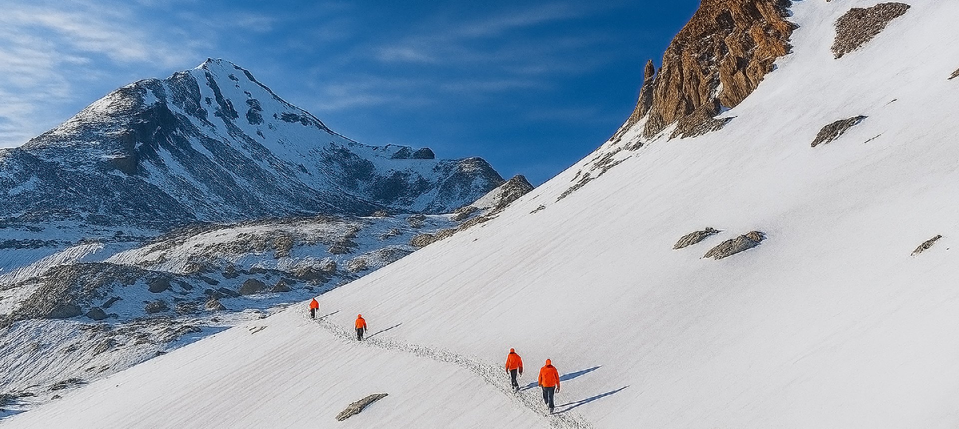
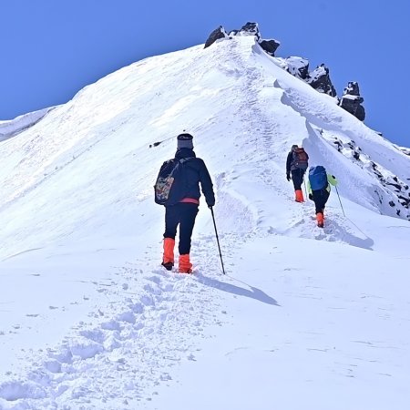
Today is the day everyone’s secretly waiting for, and the excitement to climb the summit (zero point) is high among trekkers. The day kicks off with a nutritious breakfast, and the 6-km trek to the Pindari glacier’s zero point starts. The air is chilly, seeing as we are closer to the snow-laden Himalayas, so wearing layers is a non-negotiable.
The start hits you with a 200 m steep ascent that leads you to cross a thick ice bridge over a small glacial stream. Right after, you are in a bugyal rich in wild palak, also called “bathua” or “Lamb's Quarters.” Adding to this, alongside Mt. Nanda Khat, Mt. Panwali Dwar (6,663 m) also shows itself. They’re both your companions for the rest of your trek.
The trail then brings you to fields adorned with buransh groves (or thickets), with beautiful clusters of pink blooms on them. Apart from a few bhoj trees, no signs of trees; therefore, forests are in sight. The landscape shifts completely, and you have ice bridges, narrow lanes, and PWD benches (for resting) sprawled on the large green fields. The wildflowers that change the landscape ever so often are the drumstick primrose, or Primula denticulata.
The Pindar River flows at 50-60 m below the trail, in the valley, and the soft gurgling water never leaves the background. Waterfalls coming from the peaks enrich the experience as they fall into the Pindar River. As you near the glacier, the sound of the waterfalls slowly tunes out.
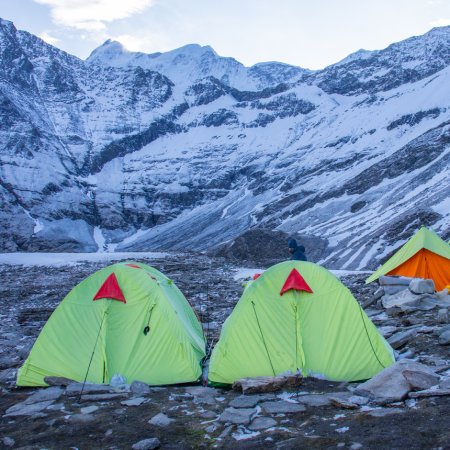
After you go around a huge mountain, you are in a field rich in buransh thickets, which is popular for more than the land painted pink. It’s here that you start seeing the Pindari Glacier, closer than ever before, and also where you get rare sightings of the Himalayan monal. A trek 20 minutes further from here brings you to a level field, where you see Maa Nanda Devi’s temple, Pindari Baba’s कुटिया (hut), and shepherd huts. This is where Pindari Baba or Swami Dharmanand stays for the summer, and the trekkers camp, if they want.
The zero point of Pindari Glacier remains at a 1-2 km distance from here. You reach the beginning of the lateral moraine ridge of the Pindari glacier and start ascending to the zero point. The giveaways of this trail will be the increasing proximity of the Pindari Glacier and a board that confirms your arrival at the zero point. The zero point magnifies the glacier’s grandeur, making it a second-to-none experience. It’s nothing like before, when the glacier used to appear like a river flowing into the valley. It has receded significantly, and even the snout is barely visible from the zero point. For a clearer view of the snout, one needs to do either of the following:
Cross the valley
Trek along the river towards the glacier
From the zero point, other views include Mt. Balijuri (5,922 m), Mt Changuch (6,322 m), and Mt. Nanda Kot (6,861 m) on the Pindari Glacier’s east, and Mt. Nanda Khat, Mt. Nanda Devi East, and Mt. Panwali Dwar on the west.
The apex of the Pindari glacier is called Traill’s Pass, and the Traill’s Pass trekking expedition takes around 12-13 days. On your way back, it takes comparatively less time to reach Phurkiya from Zero point. It’s time to rest, share stories, and experiences.
Khati Village Altitude: 7,350 ft (2,240 m)
Dwali Altitude: 8,580 ft (2,615 m)
Altitude Loss: 3,160 ft (963 m)
Trek Distance: 18 km (approx.)
Travel Hours: 8 hrs (approx.)
Today, you trek down the familiar trails, leave behind the familiar trees, and try to capture what you couldn’t on your way up. It’s a do-over that every trekker gets, especially if the zero point’s high had you in a chokehold.
You will come down at Jwarpani again, where on your side of the river, a herd of sheep greets you, while a small herd of Himalayan Ibex on the other side. Watch their subtle habits, the way the wild teaches survival without human hands.
A few meters from there, take time to look at the 1000s of meters long waterfall, which is constantly flowing, with no difference from a day or two prior. Eventually, you are at Dwali, and its geographical positioning makes you look at it with wonder.
When you cross the same makeshift bridges and landslide zones to finally reach the suspension bridge, the 2013 floods and history behind the bridge will bring a feeling of nostalgia. Finally, at Khati, enjoying the quiet sunset, you will miss the views of Mt. Nanda Devi East from Dwali and Mt. Nanda Khat from Phurkiya. They feel impossibly far and impossibly close at once.
Kathgodam Altitude: 1,490 ft (454 m)
Altitude Loss: 5,860 ft (1,786 m)
Travel Distance: 220 km (approx.)
Travel Hours: 11 hrs (approx.)
It’s time for a wrap as you see the sunrise at Khati Village, and all the memories of this short but rewarding trek come flooding in. Today is also a time to soak in the beauty of this last village. Learn how people survived here for centuries. Khati has beautiful views of snow-clad Himalayan peaks. Their beauty only increases with the sunlight falling on them, and a clear blue sky in the backdrop.
At Khati, you will realise that this region is not only famous for the Pindari Glacier trek, but also treks like Kafni Glacier, Maiktoli Glacier, and Sundardhunga Glacier. Some visit-worthy places of religious significance include Badiyakot Maa Bhagwati Mandir (temple) and Karmi Chilta Mandir.
The route from Khati to Kapkot is not as smooth, considering that the motorable road only reached Khati in 2024-2025; it is understandable. The route compensates for the discomfort with the views of the hills against a backdrop of blue sky. During evenings, the sunlit hilltops are like magic and keep you awestruck.
Way back is like the re-run of your favourite movie, you go back through the same spiralling roads, get a jumpscare or two at the sharp turns on bends, and eventually reach Kathgodam. The way back is much more fun because, if your schedule allows, you can choose to stay at Almora, Kainchi, and Bhimtal. For someone who’s all in, just nearby are Nainital, Naukuchiatal, Sattal, and Kamal Tal.
Accommodation
Meals (Vegetarian only )
Nutritious meals from Day 1's dinner to last day's breakfast, following the itinerary schedule.
Expert Support
First Aid Preparedness
Fully equipped medical kit including a stretcher, oxygen cylinder, blood pressure monitor, oximeter, and stethoscope to ensure safety throughout the journey.
Storage Facilities :- A secure room at the base camp to store additional luggage not needed during the trek.
Permits and Entry Fees :- Coverage of all necessary permits and entry fees, in line with standard charges for Indian nationals.
Transportation :- A round-trip transport from the pick-up point and back at the same point as a part of the itinerary.
Trek Equipment
Insurance :- Personal insurance is mandatory and not included in the package.
Personal Expenses :- Any expenses of a personal nature, including shopping, snacks, hiring a mule or porter for carrying your belongings, or acquiring personal equipment.
Emergency Costs :- Expenses arising from emergency evacuations, hospitalization, or any medical treatments required.
Unspecified Services :- Any services or items not explicitly mentioned under the "INCLUSIONS" section.
Food Costs :- We will not cover any food costs during your transit to and from the base village.
Trekking is not only about enjoying the change of scenery but also about being responsible. Our (Trekking Compass) responsibility is to provide you with an opportunity for a safe trek. But, how do we do that? We do that when you fulfill your end of the responsibility and are honest with us. To keep you safe we need to be sure there isn’t any inherent threat to your being.
Treks are at higher altitudes and it becomes difficult, almost impossible to provide you with immediate medical assistance. Therefore, we cannot help you if you don’t help us. Trekking is only one of the things you can do, but there are plenty of other things to do too. Don’t risk your life for the thrill.
To approach a trek with utmost safety, we want you to submit the following documents:
Personal Confirmation Statement (Compulsory for anyone over 18 years)
You are participating in a trek at high altitudes and it comes with its own sets of risks. This Personal Confirmation Statement will make sure that you understand all the risks you're buying into. Trekking Compass wants you to confirm your complete understanding of these risks so that you come prepared for any mental or physical challenges ahead.
This statement is also a declaration from you that, "All the information I have provided, including medical conditions, is true. If found false under any circumstances, I will be held accountable and it has nothing to do with Trekking Compass."
We have the utmost empathy for you and will do our best to help wherever possible, but only after assessing your readiness and safety for the trek. This is how our team will adequately prepare for whatever risks we might face during the journey. Concerning individuals are requested to thoroughly cross-check the requirements and only then sign the document.
Parent/Guardian Approval Statement (Compulsory for anyone below 18 years)
For participants under 18 years of age, the Parent/Guardian Approval Statement is essential to confirm that a legal guardian understands and consents to the participation in the trek. Once we have this document, we are affirmed that the parent or guardian is fully aware of the risks involved in trekking at high altitudes and is consenting to their child's participation.
No underage (below 18+) children are welcome on the trek without their parent's consent. Submission of this document reassures us that parents are approving that their child meets the health and fitness requirements for the trek, after a thorough examination.
This legal confirmation holds the parent liable for any discrepancies, freeing Trekking Compass from any liabilities for the same. Parents are requested to thoroughly cross-check the requirements and only then sign the document.
Medical Liability Waiver
The Medical Liability Waiver makes sure participants acknowledge the health risks associated with trekking at high altitudes. Common ailments during treks include altitude sickness, dehydration, muscle cramps, hypothermia, and fatigue, all of which can significantly affect your trekking experience. Additionally, weather changes and the physical demands of the terrain may exacerbate pre-existing conditions.
If you have pre-existing medical conditions such as asthma, diabetes, or heart issues, it’s vital to inform us and carry your necessary medications. Trekking Compass cannot provide immediate medical assistance in remote areas, so having the essential medications, such as inhalers, insulin, or any other prescriptions, is crucial for your safety during the trek.
By signing this waiver, you confirm that you are in good health and have taken the necessary precautions. You acknowledge these risks and agree not to hold Trekking Compass liable for any medical issues or accidents that may arise during the trek.
For any further doubts about anything mentioned above, below is our contact information:
OFFICE ADDRESS: Lane No. 4 Krishna Vihar Mohkampur, Dehradun, Uttarakhand, 248005
PHONE NUMBER: +91 7055048487, 7055048488
EMAIL ADDRESS: info@trekkingcompass.com
Kathgodam (How to Reach)
Any trek in the Kumaon Himalayas most likely requires your arrival at Kathgodam, where you meet our (Trekking Compass) team. Kathgodam is famous for its railway station and the highway, which has roads diverging into every district in the Kumaon region. For the Pindari Glacier trek, too, you’ll arrive here, roughly 310 km from Delhi and 220 km from Khati village.
When traveling in Uttarakhand, always factor in its fragile weather and terrain. A buffer day is essential to avoid unexpected disruptions. If it remains unused, you can spend it exploring Nainital, Bhimtal, or other nearby spots
The trek itself spans 6 days and 5 nights, but we recommend keeping 7 days and 6 nights free in your schedule.
Reaching Kathgodam from Delhi
Your place (anywhere in India) to Delhi and then to Kathgodam is the most feasible way to reach Kathgodam. Trekkers from nearby states such as Himachal, J&K, Ladakh, Punjab, Haryana, and Uttar Pradesh, including Uttarakhand, are welcome to try alternate routes. But for the majority, Delhi remains the best option, and here’s why:
Medium: BUS
Delhi to Kathgodam:
Several state-run and private operators provide comfortable AC Volvo bus services. Opting for government-operated buses is advisable. They avoid delays and adhere to schedules, thus being more reliable than private operators.
Note: Buses from Delhi drop you at Haldwani Bus Station, near Prem Talkies and a petrol pump. From here, hop on a local tuk-tuk or auto for ₹20–40. The ride takes about 20 minutes to cover the 4–5 km stretch to Kathgodam Railway Station.
Medium: TRAIN
Delhi to Kathgodam Railway Station:
Train Options: 3 major trains are available from New Delhi Railway Station to Kathgodam Railway Station.
Duration: Approximately 6 hours.
| S.No. | Name of the Train | Train Code | Time Schedule |
| 1. | Kathgodam Shatabdi Express | 12040 | 6:20 am to 11:55 am |
| 2. | Uttaranchal Sampark Kranti Express | 15035 | 4:00 pm to 10:45 pm |
| 3. | Ranikhet Express (Overnight Train) | 15013 | 10:05 pm to 5:05 pm |
Note: Make sure to hop off at Kathgodam Railway Station, where our team awaits you. Haldwani Railway Station isn’t well equipped, and trains halting at Lal Kuan will still require an additional 30-minute ride back to Kathgodam.
Medium: FLIGHT
Fly Directly to Pantnagar Airport:
Nearest Airport to Kathgodam: The Pantnagar Airport is the most proximate airport to Kathgodam, located approximately 15 km from Rudrapur Bus Depot. From Rudrapur, take a bus to Haldwani Bus Stand (32 km). From there, a short auto or tuk-tuk ride will get you to Kathgodam Railway Station.
Flight Options: Direct flights only from Delhi. Layover flights from Lucknow and Dehradun are also available.
Duration: Around 1 hour.
Due to weather conditions, flights can be unpredictable, so it's essential to check schedules and availability in advance. Flights aren’t recommended; choose trains instead.
Note: Ensure that your chosen mode of transport brings you to Kathgodam a day before the trek commences (Day 0). This allows acclimatization and preparation.
Flights to Delhi are available from major cities like Mumbai, Kolkata, Bengaluru, Chennai, and Hyderabad. From Delhi, you can proceed to Kathgodam using any of the options above.
What happens on the drop-off day?
While scheduling your onward travel from Kathgodam, do consider potential delays due to weather or road conditions. Therefore, either schedule it,
Special Case: What if you miss our pick-up?
If you miss the scheduled pick-up, here are alternative ways to reach Khati village, the trek’s starting point:
| Backpack with rain cover / Trolley Bag | Main bag for gear. |
| Day pack with rain cover (20 - 30 L) | For day essentials, if the main pack is off-loaded. |
| Walking stick | Recommended (at least one). |
| Water bottle/ Hydration pack | 2 bottles (1L each) or 1 hydration pack and 1 bottle. |
| Snacks | Energy bars, dry fruits, ORS/electrolytes. |
| Personal Medical Kit | As prescribed by your doctor. |
| T-shirts (Synthetic, quick-dry) | 2 full-sleeve, 2 half-sleeve. |
| Fleece T-shirts | 2 pieces. |
| Wind-stopper / Fleece jacket (upper) | 1 piece. |
| Windproof jacket | 1 piece |
| Down feather / Hollow jacket | 1 piece |
| Thermal innerwear (Upper & Lower) | 1 set. |
| Trekking pants (Synthetic, quick-dry) | 3 pairs. |
| Wind-stopper / Fleece pants (lower) | 1 pair. |
| Waterproof gloves | Not required. |
| Fleece / Woolen gloves | 1 pair. |
| Poncho / Waterproof jacket and pants | 1 set. |
| Head torch / Hand torch | 1 piece. |
| Sun cap | Required. |
| Woolen cap | 1 piece. |
| Balaclava | 1 piece. |
| Buff/ Neck gaiters | 1 synthetic, 1 woolen. |
| Sunglasses | UV protection with side covers (for spectacle users: contacts or photochromatic lenses). |
| Trekking shoes (waterproof, high ankle, good grip) | 1 pair. |
| Floaters / Flip-flops | 1 pair. |
| Cotton socks | 4 pairs. |
| Woolen socks | 2 pair. |
| Sunscreen | 1 piece. |
| Moisturizer | 1 piece. |
| Lip balm/ Chap-stick | 1 piece. |
| Toothbrush and toothbrush | 1 set. |
| Toilet paper and wipes | 1 pack each. |
| Soap/ Hand sanitizer | 1 piece. |
| Quick-dry towel | 1 piece. |
The Pindari Glacier Trek is best undertaken in May–June and September–October. In summer, trekkers enjoy lush meadows, snow melting into streams, and blooming rhododendrons along the trail. Post-monsoon, the air is clearer, offering majestic views of Nanda Devi, Nanda Kot, and Maiktoli peaks. Monsoon is not recommended due to landslides, and winter makes the region snowbound.
The glacier is popularly called the “Soul of Kumaon”. It is the source of the Pindar River, a major tributary of the Alaknanda, and lies between the Nanda Devi and Nanda Kot massifs. The glacier snout at zero point (3,660 m) is a spectacular sight, surrounded by towering ice walls.
The trek is rated easy to moderate. It has well-laid trails, gradual ascents, and is considered one of the safest glacier treks in Uttarakhand. This makes it an excellent choice for first-time Himalayan trekkers, families, and school/college groups.
The trek covers around 52 km (round trip) and takes 5-6 days. Starting from Khati village, trekkers pass through villages, forests, and riverside trails before reaching the glacier.
The trek reaches up to 3,660 m (12,200 ft) at the glacier’s zero point. While this is relatively moderate compared to other high-altitude treks, the panoramic view is unforgettable.
No. The Pindari Glacier Trek is beginner-friendly, making it perfect for those attempting their first Himalayan trek. However, being physically active helps in covering long walking days.
Trekkers should be able to walk 8–10 km per day comfortably with a small backpack. Light jogging, stair climbing, and endurance training before the trek help in preparation.
Unlike remote treks, Pindari offers a mix of GMVN guesthouses, local homestays, and tented camping. Villages like Khati, Dwali, and Phurkia provide rest stops, making it one of the more comfortable Himalayan treks.
Permits from the forest department are mandatory since the trek passes through reserve forest areas. Your Pindari Glacier Trek package with Trekking Compass includes all required paperwork, so you don’t need to worry about arranging them separately.
The trek begins from Loharkhet (near Bageshwar), which can be reached from Kathgodam or Haldwani by road. Bageshwar is the central hub, from where vehicles go to the starting point.
No, since the altitude remains below 4,000 m, the risk of AMS (acute mountain sickness) is very low compared to treks like Roopkund or Bali Pass.
Yes, it is one of the safest and most popular treks in Kumaon. The trail is well-established, and villages along the way provide safety and support. Still, weather precautions are important.
Because it is one of the most accessible glacier treks in India, combining adventure with cultural richness. It introduces beginners to Himalayan trekking, offers incredible glacier views, and provides glimpses of Kumaoni traditions along the way — all without extreme altitude challenges.
Handpicked routes with strong scenery, reliable pacing, and a premium featured block that still stands apart from the rest of the archive page.
Crafted routes, reliable execution, and a trekking experience that feels premium from planning to summit.
 Safety
Route checks, first-aid readiness, and trained leaders to keep every step confident.
 Routes
Better pacing, better camps, and real acclimatization designed for experience, not speed.
 Groups
Less crowd, more care so you enjoy the trek, not just finish it.
 Trust
Trust
Clear inclusions, no hidden surprises, and real human support on WhatsApp.